Sabugal - Cabeco Da Vaca
Airport details
| Country | Portugal |
| State | [Other] |
| Region | |
| Airspace | Lisbon Ctr |
| Municipality | Souto |
| Elevation | 3116ft (950m) |
| Timezone | GMT +0 |
| Coordinates | 40.34395, -6.98028 |
| Magnetic var | |
| Type | land |
| Available since | X-Plane v11.33 |
| ICAO code | XLP0066 |
| IATA code | n/a |
| FAA code | n/a |
Communication
Nearby Points of Interest:
Castle of Eljas
-Meimoa
-Santuário de Nossa Senhora da Ajuda
-Igreja Matriz de São Miguel de Malhada Sorda
-Ponte da Ribeira de Meimoa
-Penamacor
-Castro de Irueña
-Convento de Nossa Senhora da Boa Esperança
-Anta de Pêra do Moço
-Muralha romana de Idanha-a-Velha
-Egitania
-Castelo de Idanha-a-Velha
-Corpo da Guarda Principal em Almeida
-Praça-forte de Almeida
-Muralhas da Cidade da Covilhã
-Saelices el Chico roman villa
-Palacio de Montarco, Ciudad Rodrigo
-Igreja de Santa Maria (Celorico da Beira)
-Ciudad Rodrigo
-Igreja da Misericórdia de Pinhel
-Casa Grande (Pinhel)
-Torre Solar dos Metelos
-Chapel of Santa Marta (Gouveia)
-Castelo de Salvaterra do Extremo
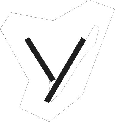
Runway info
Runway 04 / 22  | ||
| length | 261m (856ft) | |
| bearing | 43° / 223° | |
| width | 20m (66ft) | |
| surface | grass | |
| Runway 15 / 33 | ||
| length | 171m (561ft) | |
| bearing | 145° / 325° | |
| width | 20m (66ft) | |
| surface | grass | |
Nearby beacons
| code | identifier | dist | bearing | frequency |
|---|---|---|---|---|
| VIS | VISEU VOR/DME | 47.1 | 293° | 113.10 |
| CCS | CACERES VOR/DME | 55.2 | 146° | 114.20 |
| NSA | NISA VOR/DME | 63.5 | 230° | 115.50 |
| DMR | DME | 68.1 | 315° | 114.60 |
Disclaimer
The information on this website is not for real aviation. Use this data with the X-Plane flight simulator only! Data taken with kind consent from X-Plane 12 source code and data files. Content is subject to change without notice.