Livno
Airport details
| Country | Bosnia and Herzegovina |
| State | Federation of Bosnia and Herzegovina |
| Region | LQ |
| Airspace | Sarajevo Ctr |
| Municipality | City of Livno |
| Elevation | 2333ft (711m) |
| Timezone | GMT +1 |
| Coordinates | 43.79167, 16.89361 |
| Magnetic var | |
| Type | land |
| Available since | X-Plane v10.40 |
| ICAO code | XLQ0004 |
| IATA code | n/a |
| FAA code | n/a |
Communication
| Livno Livno Info | 123.500 |
Nearby Points of Interest:
Forteresse de Livno
-Lala Pašina džamija
-église de la Dormition-de-la-Mère-de-Dieu de Livno
-Hadzi Ahmeta Dukatar's Mosque
-Balaguša džamija
-Livanjsko Polje
-Immaculate Conception church
-St. Nikola Tavelić church
-Crljivica
-Historical Complex of Split with the Palace of Diocletian
-Splitska sinagoga
-Janj
-Virgin Mary Church
-Dugopolje necropolis
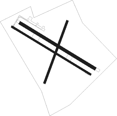
Runway info
Runway 13R / 31L  | ||
| length | 846m (2776ft) | |
| bearing | 117° / 297° | |
| width | 18m (59ft) | |
| surface | asphalt | |
| displ threshold | 40m (131ft) / 0m (0ft) | |
| Runway 13L / 31R | ||
| length | 798m (2618ft) | |
| bearing | 117° / 297° | |
| width | 30m (98ft) | |
| surface | grass | |
| Runway 02 / 20 | ||
| length | 601m (1972ft) | |
| bearing | 32° / 212° | |
| width | 20m (66ft) | |
| surface | grass | |
Nearby beacons
| code | identifier | dist | bearing | frequency |
|---|---|---|---|---|
| VRL | VRLIKA NDB | 21.6 | 287° | 283 |
| SPL | SPLIT VOR/DME | 31.1 | 243° | 115.70 |
| HUM | HUMAC (BRAC) NDB | 31.7 | 203° | 412 |
| BRC | DME | 32.7 | 208° | 115.45 |
| TRI | TROGIR NDB | 34.1 | 246° | 378 |
| DVN | DRVENIK NDB | 38.6 | 245° | 418 |
| MSR | MOSTAR VOR/DME | 52.6 | 119° | 116.90 |
| MA | MOSTAR NDB | 54.2 | 121° | 355 |
| DNC | MOSTAR NDB | 57.2 | 124° | 425 |
Disclaimer
The information on this website is not for real aviation. Use this data with the X-Plane flight simulator only! Data taken with kind consent from X-Plane 12 source code and data files. Content is subject to change without notice.