Gloriavale Christian Church - Lake Haupiri
Airport details
| Country | New Zealand |
| State | West Coast |
| Region | |
| Municipality | Grey District |
| Elevation | 659ft (201m) |
| Timezone | GMT +13 |
| Coordinates | -42.59905, 171.69597 |
| Magnetic var | |
| Type | land |
| Available since | X-Plane v10.40 |
| ICAO code | XNZLH |
| IATA code | n/a |
| FAA code | n/a |
Communication
Nearby Points of Interest:
Kotuku Model Bungalow
-Brunner Mine
-Runanga Miners' Hall
-Hannah's Buildings
-Dispatch & Garlick
-Reefton Power Station
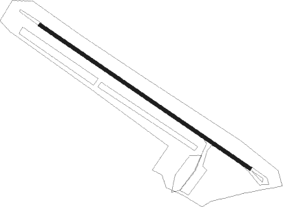
Runway info
| Runway 13 / 31 | ||
| length | 697m (2287ft) | |
| bearing | 121° / 301° | |
| width | 10m (33ft) | |
| surface | asphalt | |
Nearby beacons
| code | identifier | dist | bearing | frequency |
|---|---|---|---|---|
| HK | HOKITIKA NDB | 33.5 | 260° | 310 |
| WS | WESTPORT NDB | 51.7 | 352° | 278 |
| WS | PORT DME | 51.8 | 352° | 116.90 |
| CH | CHRISTCHURCH VOR/DME | 65.1 | 138° | 115.30 |
Disclaimer
The information on this website is not for real aviation. Use this data with the X-Plane flight simulator only! Data taken with kind consent from X-Plane 12 source code and data files. Content is subject to change without notice.