Zakher
Airport details
| Country | United Arab Emirates |
| State | Abu Dhabi Emirate |
| Region | |
| Airspace | Emirates Ctr |
| Municipality | Al Qisees |
| Elevation | 714ft (218m) |
| Timezone | GMT +4 |
| Coordinates | 24.10838, 55.60645 |
| Magnetic var | |
| Type | land |
| Available since | X-Plane v10.40 |
| ICAO code | XOMAP |
| IATA code | n/a |
| FAA code | n/a |
Communication
Nearby Points of Interest:
Al Ain
-Cultural Sites of Al Ain (Hafit, Hili, Bidaa Bint Saud and Oases Areas)
-Bidaa Bint Saud
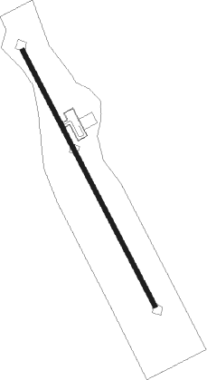
Runway info
| Runway 15 / 33 | ||
| length | 1348m (4423ft) | |
| bearing | 155° / 335° | |
| width | 20m (66ft) | |
| surface | asphalt | |
Nearby beacons
| code | identifier | dist | bearing | frequency |
|---|---|---|---|---|
| ALN | AL AIN VOR/DME | 9 | 360° | 112.60 |
| ALA | AL AIN VOR/DME | 10.4 | 3° | 115.90 |
| ADV | ABU DHABI VOR/DME | 54.3 | 288° | 114.25 |
| MIN | MINHAD VOR/DME | 56.3 | 347° | 115.20 |
| FJV | FUJAIRAH VOR/DME | 72.2 | 37° | 113.80 |
Disclaimer
The information on this website is not for real aviation. Use this data with the X-Plane flight simulator only! Data taken with kind consent from X-Plane 12 source code and data files. Content is subject to change without notice.