Kent - Rancho Del Cielo
Airport details
| Country | United States of America |
| State | Texas |
| Region | K4 |
| Airspace | Albuquerque Ctr |
| Municipality | Jeff Davis County |
| Elevation | 4411ft (1344m) |
| Timezone | GMT -6 |
| Coordinates | 31.01528, -104.21242 |
| Magnetic var | |
| Type | land |
| Available since | X-Plane v10.40 |
| ICAO code | XS44 |
| IATA code | n/a |
| FAA code | XS44 |
Communication
| Rancho Del Cielo CTAF/UNICOM | 122.975 |
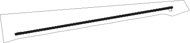
Runway info
| Runway 8 / 26 | ||
| length | 1916m (6286ft) | |
| bearing | 85° / 265° | |
| width | 23m (75ft) | |
| surface | asphalt | |
Nearby beacons
| code | identifier | dist | bearing | frequency |
|---|---|---|---|---|
| XAA | KENT NDB | 0.2 | 104° | 225 |
| VHN | VAN HORN NDB | 29.6 | 275° | 233 |
| PEQ | PECOS (PECOS CITY) VOR/DME | 42.6 | 55° | 111.80 |
| BWR | BREWSTER COUNTY (ALPINE) NDB | 44.4 | 135° | 412 |
| MRF | MARFA VOR/DME | 45 | 160° | 115.90 |
| SFL | SALT FLAT VORTAC | 62.8 | 310° | 113 |
| INK | WINK VORTAC | 71.6 | 48° | 112.10 |
Disclaimer
The information on this website is not for real aviation. Use this data with the X-Plane flight simulator only! Data taken with kind consent from X-Plane 12 source code and data files. Content is subject to change without notice.