Wooloomanata
Airport details
| Country | Australia |
| State | Victoria |
| Region | YM |
| Airspace | Melbourne Ctr |
| Municipality | Little River |
| Elevation | 203ft (62m) |
| Timezone | GMT +11 |
| Coordinates | -37.93661, 144.37303 |
| Magnetic var | |
| Type | land |
| Available since | X-Plane v10.40 |
| ICAO code | XY0011 |
| IATA code | n/a |
| FAA code | n/a |
Communication
| Wooloomanata CTAF | 118.800 |
Nearby Points of Interest:
Moorabool railway station
-Osborne House
-Lethbridge railway station
-Geelong Customs House
-Geelong Town Hall
-Geelong Post Office building
-Melton Viaduct
-Meredith railway station
-Reedy Lake
-CFA Training College
-Baker House
-Swan Bay
-Barwon Heads Bridge
-West Channel Pile Light
-Newport Workshops
-Maribyrnong River Viaduct
-Williamstown Lighthouse
-Bells Beach
-Footscray Town Hall
-Sunbury Asylum
-Victoria Dock
-Station Pier
-Saltwater River Rail Bridge
-Melbourne Showgrounds
-Port Melbourne railway station
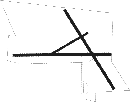
Runway info
Runway 15 / 33  | ||
| length | 797m (2615ft) | |
| bearing | 146° / 326° | |
| width | 23m (75ft) | |
| surface | grass | |
| Runway 09 / 27 | ||
| length | 838m (2749ft) | |
| bearing | 93° / 273° | |
| width | 23m (75ft) | |
| surface | grass | |
| Runway 06 / 24 | ||
| length | 377m (1237ft) | |
| bearing | 69° / 249° | |
| width | 18m (59ft) | |
| surface | grass | |
Nearby beacons
| code | identifier | dist | bearing | frequency |
|---|---|---|---|---|
| AV | AVALON VOR/DME | 7.8 | 143° | 116.10 |
| ML | MELBOURNE VOR/DME | 27.7 | 59° | 114.10 |
| MB | MOORABBIN (MELBOURNE) NDB | 34 | 93° | 398 |
Disclaimer
The information on this website is not for real aviation. Use this data with the X-Plane flight simulator only! Data taken with kind consent from X-Plane 12 source code and data files. Content is subject to change without notice.