Gnarwarre - Barwon Field
Airport details
| Country | Australia |
| State | Victoria |
| Region | YM |
| Airspace | Melbourne Ctr |
| Municipality | Surf Coast Shire |
| Elevation | 258ft (79m) |
| Timezone | GMT +11 |
| Coordinates | -38.14694, 144.17250 |
| Magnetic var | |
| Type | land |
| Available since | X-Plane v10.40 |
| ICAO code | XY001L |
| IATA code | n/a |
| FAA code | n/a |
Communication
| Barwon Field CTAF | 119.000 |
Nearby Points of Interest:
Moorabool railway station
-Geelong Town Hall
-Geelong Post Office building
-Osborne House
-Geelong Customs House
-Lethbridge railway station
-Reedy Lake
-Bells Beach
-Barwon Heads Bridge
-Meredith railway station
-Swan Bay
-Lake Beeac
-West Channel Pile Light
-CFA Training College
-South Channel Pile Light
-Melton Viaduct
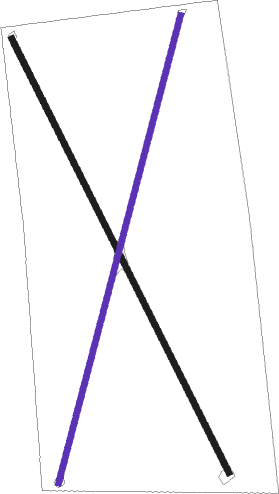
Runway info
Runway 15 / 33  | ||
| length | 988m (3241ft) | |
| bearing | 153° / 333° | |
| width | 12m (39ft) | |
| surface | grass | |
| Runway 02 / 20 | ||
| length | 984m (3228ft) | |
| bearing | 24° / 204° | |
| width | 12m (39ft) | |
| surface | grass | |
Nearby beacons
| code | identifier | dist | bearing | frequency |
|---|---|---|---|---|
| AV | AVALON VOR/DME | 14.7 | 71° | 116.10 |
| ML | MELBOURNE VOR/DME | 43.1 | 54° | 114.10 |
| MB | MOORABBIN (MELBOURNE) NDB | 44.5 | 79° | 398 |
Disclaimer
The information on this website is not for real aviation. Use this data with the X-Plane flight simulator only! Data taken with kind consent from X-Plane 12 source code and data files. Content is subject to change without notice.