Empire
Airport details
| Country | United States of America |
| State | Michigan |
| Region | |
| Airspace | Minneapolis Ctr |
| Municipality | Empire Township |
| Elevation | 942ft (287m) |
| Timezone | GMT -5 |
| Coordinates | 44.79308, -86.00385 |
| Magnetic var | |
| Type | land |
| Available since | X-Plane v10.40 |
| ICAO code | Y87 |
| IATA code | n/a |
| FAA code | Y87 |
Communication
| Empire CTAF | 122.900 |
Nearby Points of Interest:
Empire School
-Platte River Campground Site
-Port Oneida Rural Historic District
-Benzie County Courthouse
-Mills Community House
-Gwen Frostic Studio
-Point Betsie Light
-Frankfort Land Company House
-Navigation Structures at Frankfort Harbor
-George Conrad Hutzler Farm
-Bingham District No. 5 Schoolhouse
-Campbell-DeYoung Farm
-William and Margaret McFarland Core Farm
-Hutzler's Barn
-Traverse City State Hospital
-Central Neighborhood Historic District
-Fountain Point
-Lake Leelanau Narrows Bridge
-Watervale
-Leland Historic District (Leland, Michigan)
-Leelanau Transit Company Suttons Bay Depot
-Camp Arcadia
-Bowers Harbor Inn
-John Pulcipher House
-Omena Historic District
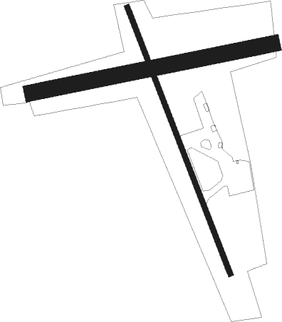
Runway info
Runway 17 / 35  | ||
| length | 793m (2602ft) | |
| bearing | 157° / 337° | |
| width | 15m (50ft) | |
| surface | asphalt | |
| displ threshold | 220m (722ft) / 56m (184ft) | |
| Runway 09 / 27 | ||
| length | 680m (2231ft) | |
| bearing | 85° / 265° | |
| width | 46m (150ft) | |
| surface | grass | |
Nearby beacons
| code | identifier | dist | bearing | frequency |
|---|---|---|---|---|
| TVC | TRAVERSE CITY VOR/DME | 20.7 | 105° | 114.60 |
| TV | GWENN (TRAVERSE CITY) NDB | 24.7 | 96° | 365 |
| MB | JEPOT (MANISTEE) NDB | 31.9 | 195° | 254 |
| MBL | DME | 33.1 | 206° | 111.40 |
| MA | WEXOR (CADILLAC) NDB | 38.6 | 141° | 336 |
Disclaimer
The information on this website is not for real aviation. Use this data with the X-Plane flight simulator only! Data taken with kind consent from X-Plane 12 source code and data files. Content is subject to change without notice.