Armidale
Airport details
| Country | Australia |
| State | New South Wales |
| Region | YB |
| Airspace | Brisbane Ctr |
| Municipality | Armidale |
| Elevation | 3556ft (1084m) |
| Timezone | GMT +10 |
| Coordinates | -30.52806, 151.61722 |
| Magnetic var | |
| Type | land |
| Available since | X-Plane v10.30 |
| ICAO code | YARM |
| IATA code | ARM |
| FAA code | n/a |
Communication
| Armidale ARMIDALE MULT | 124.200 |
| Armidale ACTIVATE LIGHTS ONLY MULT | 120.600 |
| Armidale BRISBANE CNTR | 125.750 |
Nearby Points of Interest:
Commercial Bank of Australia Building, Armidale
-Armidale Post Office
-Booloominbah
-Roseneath, Armidale
-Dumaresq railway station
-Captain Thunderbolt's Grave
-Uralla railway station
-Captain Thunderbolt's Rock
-Black Mountain railway station
-Captain Thunderbolt's death site
-Guyra railway station
-Walcha Road railway station
-St. Andrew's Anglican Church
-Macdonald River railway bridge, Woolbrook
-Ben Lomond railway station
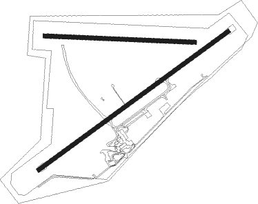
Runway info
Runway 05 / 23  | ||
| length | 1735m (5692ft) | |
| bearing | 62° / 242° | |
| width | 30m (98ft) | |
| surface | asphalt | |
| Runway 09 / 27 | ||
| length | 1111m (3645ft) | |
| bearing | 96° / 276° | |
| width | 30m (98ft) | |
| surface | grass | |
Nearby beacons
| code | identifier | dist | bearing | frequency |
|---|---|---|---|---|
| ARM | DME | 0 | 280° | 112.60 |
| ARM | ARMIDALE NDB | 0.1 | 289° | 401 |
| IVL | INVERELL NDB | 45.8 | 323° | 260 |
| TW | TAMWORTH VOR/DME | 51.8 | 236° | 116 |
| TW | TAMWORTH NDB | 52 | 235° | 341 |
Instrument approach procedures
| runway | airway (heading) | route (dist, bearing) |
|---|---|---|
| RW05 | ARMWD (42°) | ARMWD 6100ft ARMWI (5mi, 347°) 6100ft |
| RW05 | ARMWE (62°) | ARMWE 6100ft ARMWI (5mi, 62°) 6100ft |
| RW05 | ARMWG (80°) | ARMWG 6100ft ARMWI (5mi, 125°) 6100ft |
| RNAV | ARMWI 6100ft ARMWF (5mi, 62°) 5260ft ARMWM (5mi, 62°) 3667ft ARMWH (4mi, 49°) (8367mi, 281°) 6100ft | |
| RW23 | ARMEA (222°) | ARMEA 6100ft ARMEI (5mi, 167°) 6100ft |
| RW23 | ARMEB (242°) | ARMEB 6100ft ARMEI (5mi, 242°) 6100ft |
| RW23 | ARMEC (261°) | ARMEC 6100ft ARMEI (5mi, 304°) 6100ft |
| RNAV | ARMEI 6100ft ARMEF (5mi, 242°) 5280ft ARMEM (5mi, 242°) 3690ft ARMET (3mi, 228°) (8362mi, 281°) 6100ft |
Disclaimer
The information on this website is not for real aviation. Use this data with the X-Plane flight simulator only! Data taken with kind consent from X-Plane 12 source code and data files. Content is subject to change without notice.