Ayr
Airport details
| Country | Australia |
| State | Queensland |
| Region | YB |
| Airspace | Brisbane Ctr |
| Municipality | Burdekin Shire |
| Elevation | 41ft (12m) |
| Timezone | GMT +10 |
| Coordinates | -19.58444, 147.32916 |
| Magnetic var | |
| Type | land |
| Available since | X-Plane v10.32 |
| ICAO code | YAYR |
| IATA code | AYR |
| FAA code | n/a |
Communication
| Ayr CTAF FSS | 126.700 |
| Ayr BRISBANE CNTR FSS | 120.550 |
| Ayr YAYR UNIC | 122.100 |
| Ayr CTAF CTAF | 126.700 |
Nearby Points of Interest:
St Patrick's Catholic Church, Brandon
-Ayr Court House
-Home Hill Powerhouse
-Radar Station, Charlie's Hill
-Bowling Green Bay National Park
-Stewart's Creek Gaol
-St Brigid's Church, Stuart
-Ross River Meatworks Chimney
-St John's Anglican Church, South Townsville
-Burns Philp Building, Townsville
-Bank of New South Wales Building, Townsville
-Australian Joint Stock Bank Building, Townsville
-Atkinson & Powell Building
-Agora House
-Aplin Brown & Company Building
-Australian Mutual Provident Society Building
-Samuel Allen & Sons Building
-Old Townsville Railway Station
-Townsville Post Office
-Tobruk Memorial Baths
-Lion Brewery, Townsville
-Rosebank
-Kardinia, Townsville
-Second Townsville General Hospital
-Picnic Bay State School
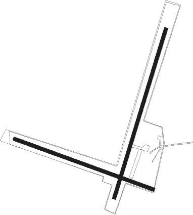
Runway info
Runway 02 / 20  | ||
| length | 1469m (4820ft) | |
| bearing | 23° / 203° | |
| width | 30m (98ft) | |
| surface | asphalt | |
| Runway 11 / 29 | ||
| length | 1228m (4029ft) | |
| bearing | 113° / 293° | |
| width | 30m (98ft) | |
| surface | grass | |
Nearby beacons
| code | identifier | dist | bearing | frequency |
|---|---|---|---|---|
| TVL | TOWNSVILLE NDB | 37.9 | 301° | 276 |
| TL | TOWNSVILLE VOR/DME | 38.2 | 301° | 114.10 |
Disclaimer
The information on this website is not for real aviation. Use this data with the X-Plane flight simulator only! Data taken with kind consent from X-Plane 12 source code and data files. Content is subject to change without notice.