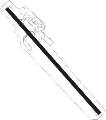
Hamilton Island - Hamilton I.
Airport details
| Country | Australia |
| State | Queensland |
| Region | YB |
| Airspace | Brisbane Ctr |
| Municipality | Whitsunday Regional |
| Elevation | 14ft (4m) |
| Timezone | GMT +10 |
| Coordinates | -20.35502, 148.95073 |
| Magnetic var | |
| Type | land |
| Available since | X-Plane v10.40 |
| ICAO code | YBHM |
| IATA code | HTI |
| FAA code | n/a |
Communication
| Hamilton I. ATIS | 128.350 |
| Hamilton I. CTAF | 127.850 |
| Hamilton I. HAMILTON IS Tower | 118.700 |
| Hamilton I. DepartureARTURE (Tower) | 118.700 |
Nearby Points of Interest:
Dent Island Light
-Proserpine Hospital
-St Paul's Anglican Church, Proserpine
Nearby beacons
| code | identifier | dist | bearing | frequency |
|---|---|---|---|---|
| HM | HAMILTON I VOR/DME | 0.3 | 53° | 114.40 |
| PN | PROSERPINE VOR/DME | 23.9 | 250° | 113.70 |
| MK | MACKAY NDB | 50.2 | 164° | 308 |
| MK | MACKAY VOR/DME | 50.8 | 164° | 112.70 |
Instrument approach procedures
| runway | airway (heading) | route (dist, bearing) |
|---|---|---|
| RW14-P | IVSUD (326°) | IVSUD 4000ft MUPOG (9mi, 314°) 4000ft HM615 (6mi, 314°) 2100ft |
| RW14-P | MUPOG (351°) | MUPOG 4000ft HM615 (6mi, 314°) 2100ft |
| RNAV | HM615 2100ft HM605 (3mi, 51°) 680ft YBHM (2mi, 140°) 62ft HM685 (6mi, 142°) 2800ft | |
| RW14-U | HM (233°) | HM 4000ft HM645 (8mi, 348°) 3000ft HM642 (2mi, 318°) 3000ft HM640 (4mi, 218°) 2400ft |
| RW14-U | MAMAG (141°) | MAMAG 4000ft HM660 (4mi, 141°) 3000ft HM640 (5mi, 142°) 2430ft |
| RNAV | HM640 2430ft HM610 (5mi, 141°) 1000ft YBHM (3mi, 141°) 62ft HM685 (6mi, 142°) 2800ft | |
| RW14-W | MAMAG (141°) | MAMAG 4000ft HM839 (4mi, 141°) 4000ft HM640 (5mi, 141°) 2430ft |
| RNAV | HM640 2430ft HM841 (3mi, 141°) 1500ft YBHM (5mi, 141°) 64ft HM685 (6mi, 142°) (8615mi, 278°) 2800ft | |
| RW14-Y | OVRON (233°) | OVRON 4000ft HM843 (5mi, 14°) 3500ft |
| RNAV | HM843 3500ft HM842 (3mi, 331°) 3500ft HM841 (5mi, 219°) 1500ft YBHM (5mi, 141°) 64ft HM685 (6mi, 142°) (8615mi, 278°) 2800ft | |
| RW14-Z | HTINA (123°) | HTINA 3900ft HTINI (5mi, 74°) 3900ft |
| RW14-Z | HTINC (141°) | HTINC 3900ft HTINI (5mi, 141°) 3900ft |
| RW14-Z | HTIND (160°) | HTIND 3900ft HTINI (5mi, 214°) 3900ft |
| RNAV | HTINI 3900ft HTINF (5mi, 141°) 2290ft HTINM (5mi, 141°) 701ft HTINH (5mi, 141°) (8615mi, 278°) 2800ft | |
| RW32-U | ANGIT (326°) | ANGIT 4000ft HM745 (3mi, 343°) 4000ft GOSVU (2mi, 334°) 4000ft HM740 (3mi, 321°) 3000ft HM735 (3mi, 321°) 2000ft HM710 (4mi, 321°) 1000ft |
| RW32-U | GOSVU (321°) | GOSVU 4000ft HM740 (3mi, 321°) 3000ft HM735 (3mi, 321°) 2000ft HM710 (4mi, 321°) 1000ft |
| RW32-U | OPOSI (354°) | OPOSI 4000ft HM720 (4mi, 355°) 3000ft HM715 (4mi, 18°) 2000ft HM710 (4mi, 2°) 1000ft |
| RNAV | HM710 1000ft YBHM (4mi, 322°) 63ft HM765 (6mi, 321°) 2800ft | |
| RW32-W | ANGIT (326°) | ANGIT 4000ft HM838 (3mi, 344°) 4000ft GOSVU (2mi, 333°) 4000ft HM836 (4mi, 321°) 2600ft |
| RNAV | HM836 2600ft HM834 (4mi, 321°) 1300ft YBHM (5mi, 322°) 65ft HM765 (6mi, 321°) 2800ft | |
| RW32-X | OPOSI (354°) | OPOSI 4000ft HM831 (4mi, 12°) 2600ft HM832 (2mi, 23°) 2600ft |
| RNAV | HM832 2600ft HM834 (4mi, 357°) 1300ft YBHM (5mi, 322°) 65ft HM765 (6mi, 321°) 2800ft | |
| RW32-Y | HTISE (303°) | HTISE 3900ft HTISI (5mi, 254°) 3900ft |
| RW32-Y | HTISG (321°) | HTISG 3900ft HTISI (5mi, 321°) 3900ft |
| RW32-Y | HTISJ (340°) | HTISJ 3900ft HTISI (5mi, 34°) 3900ft |
| RNAV | HTISI 3900ft HTISF (5mi, 321°) 2290ft YBHM (8mi, 322°) 65ft HTISH (2mi, 320°) (8614mi, 278°) 2800ft | |
| RW32-Z | HTISE (303°) | HTISE 3900ft HTISI (5mi, 254°) 3900ft |
| RW32-Z | HTISG (321°) | HTISG 3900ft HTISI (5mi, 321°) 3900ft |
| RW32-Z | HTISJ (340°) | HTISJ 3900ft HTISI (5mi, 34°) 3900ft |
| RNAV | HTISI 3900ft HTISF (5mi, 321°) 2290ft HTISM (5mi, 321°) 734ft HTISH (5mi, 321°) (8614mi, 278°) 2800ft |
Disclaimer
The information on this website is not for real aviation. Use this data with the X-Plane flight simulator only! Data taken with kind consent from X-Plane 12 source code and data files. Content is subject to change without notice.
