Bombala
Airport details
| Country | Australia |
| State | New South Wales |
| Region | YM |
| Airspace | Melbourne Ctr |
| Municipality | Bombala |
| Elevation | 2479ft (756m) |
| Timezone | GMT +11 |
| Coordinates | -36.90500, 149.18333 |
| Magnetic var | |
| Type | land |
| Available since | X-Plane v10.40 |
| ICAO code | YBOM |
| IATA code | n/a |
| FAA code | n/a |
Communication
| Bombala CTAF | 126.700 |
Nearby Points of Interest:
Bombala railway station
-Crankies Plain Bridge
-New Buildings Bridge over Towamba River
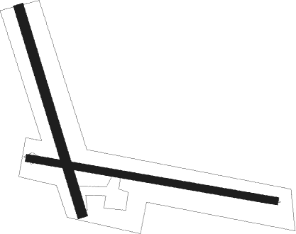
Runway info
Runway 09 / 27  | ||
| length | 770m (2526ft) | |
| bearing | 102° / 282° | |
| width | 23m (75ft) | |
| surface | grass | |
| Runway 15 / 33 | ||
| length | 657m (2156ft) | |
| bearing | 164° / 344° | |
| width | 30m (98ft) | |
| surface | grass | |
Nearby beacons
| code | identifier | dist | bearing | frequency |
|---|---|---|---|---|
| MER | MERIMBULA NDB | 34.3 | 91° | 395 |
| COM | COOMA NDB | 34.8 | 338° | 293 |
Disclaimer
The information on this website is not for real aviation. Use this data with the X-Plane flight simulator only! Data taken with kind consent from X-Plane 12 source code and data files. Content is subject to change without notice.