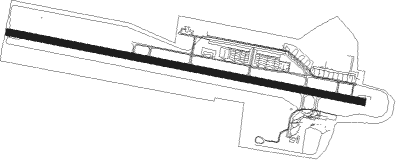
Broome - Broome Intl
Airport details
| Country | Australia |
| State | Western Australia |
| Region | YB |
| Airspace | Brisbane Ctr |
| Municipality | Shire Of Broome |
| Elevation | 56ft (17m) |
| Timezone | GMT +8 |
| Coordinates | -17.95015, 122.23750 |
| Magnetic var | |
| Type | land |
| Available since | X-Plane v10.40 |
| ICAO code | YBRM |
| IATA code | BME |
| FAA code | n/a |
Communication
| Broome Intl Broome ATIS | 133.050 |
| Broome Intl Broome AWIS | 126.550 |
| Broome Intl BROOME RADIO MULT | 126.000 |
| Broome Intl Broome CTAF | 126.000 |
| Broome Intl BRISBANE CENTRE MULT | 123.900 |
| Broome Intl BROOME UNIC | 126.000 |
| Broome Intl ACTIVATE LIGHTS ONLY MULT | 119.600 |
| Broome Intl Broome SMC | 121.700 |
| Broome Intl Broome Tower | 126.000 |
| Broome Intl Brisbane Center | 123.950 |
Nearby Points of Interest:
Broome Cable House
-Anglican Church of the Annunciation
-Broome
-Roebuck Bay
Runway info
| Runway 10 / 28 | ||
| length | 2412m (7913ft) | |
| bearing | 105° / 285° | |
| width | 45m (149ft) | |
| surface | asphalt | |
| displ threshold | 139m (456ft) / 72m (236ft) | |
| blast zone | 0m (0ft) / 142m (466ft) | |
Airport layout

Taxiway locations
Parking locations
|
Nearby beacons
| code | identifier | dist | bearing | frequency |
|---|---|---|---|---|
| BRM | BROOME NDB | 0.2 | 330° | 320 |
Instrument approach procedures
| runway | airway (heading) | route (dist, bearing) |
|---|---|---|
| RW10-U | JNORT (323°) | JNORT 4600ft RM642 (4mi, 323°) 4600ft RM638 (5mi, 304°) 4600ft BRAND (12mi, 285°) 4600ft RM606 (6mi, 16°) 1780ft |
| RW10-U | MASIM (354°) | MASIM 6000ft BRAND (15mi, 319°) 4600ft RM606 (6mi, 16°) 1780ft |
| RW10-U | MELAN (299°) | MELAN 6000ft RM646 (3mi, 292°) 6000ft RM638 (17mi, 285°) 4600ft BRAND (12mi, 285°) 4600ft RM606 (6mi, 16°) 1780ft |
| RW10-U | RUTRS (312°) | RUTRS 4600ft RM638 (13mi, 298°) 4600ft BRAND (12mi, 285°) 4600ft RM606 (6mi, 16°) 1780ft |
| RW10-U | TCART (104°) | TCART 2200ft RM606 (1mi, 105°) 1780ft |
| RNAV | RM606 1780ft YBRM (7mi, 104°) 106ft RM604 (5mi, 106°) 2200ft | |
| RW10-Z | BRMWD (86°) | BRMWD 3000ft BRMWI (5mi, 37°) 3000ft |
| RW10-Z | BRMWE (105°) | BRMWE 3000ft BRMWI (5mi, 105°) 3000ft |
| RW10-Z | BRMWG (124°) | BRMWG 3000ft BRMWI (5mi, 175°) 3000ft |
| RNAV | BRMWI 3000ft BRMWF (5mi, 105°) 1770ft BRMWM (5mi, 105°) 179ft BRMWH (3mi, 105°) (7238mi, 278°) 2100ft | |
| RW28-U | JNORT (323°) | JNORT 3000ft TEMAN (9mi, 343°) 2800ft RM604 (4mi, 323°) 1570ft |
| RW28-U | MASIM (354°) | MASIM 6000ft RM640 (10mi, 27°) 3800ft TEMAN (3mi, 31°) 2800ft RM604 (4mi, 323°) 1570ft |
| RW28-U | MELAN (299°) | MELAN 6000ft RM634 (12mi, 299°) 3200ft RM630 (3mi, 317°) 3000ft RAPLY (4mi, 310°) 2200ft RM604 (2mi, 285°) 1570ft |
| RW28-U | RAPLY (285°) | RAPLY 2200ft RM604 (2mi, 285°) 1570ft |
| RW28-U | RUTRS (312°) | RUTRS 4000ft RM624 (9mi, 312°) 3400ft TEMAN (3mi, 337°) 2800ft RM604 (4mi, 323°) 1570ft |
| RNAV | RM604 1570ft YBRM (5mi, 286°) 72ft RM606 (7mi, 284°) 2200ft | |
| RW28-Z | BRMEA (265°) | BRMEA 3000ft BRMEI (5mi, 217°) 3000ft |
| RW28-Z | BRMEB (285°) | BRMEB 3000ft BRMEI (5mi, 285°) 3000ft |
| RW28-Z | BRMEC (306°) | BRMEC 3000ft BRMEI (5mi, 355°) 3000ft |
| RNAV | BRMEI 3000ft BRMEF (5mi, 285°) 1740ft BRMEM (5mi, 285°) 149ft BRMEH (3mi, 285°) (7234mi, 278°) 2100ft |
Disclaimer
The information on this website is not for real aviation. Use this data with the X-Plane flight simulator only! Data taken with kind consent from X-Plane 12 source code and data files. Content is subject to change without notice.