Balranald
Airport details
| Country | Australia |
| State | New South Wales |
| Region | YM |
| Airspace | Melbourne Ctr |
| Municipality | Balranald |
| Elevation | 208ft (63m) |
| Timezone | GMT +11 |
| Coordinates | -34.62361, 143.57834 |
| Magnetic var | |
| Type | land |
| Available since | X-Plane v10.32 |
| ICAO code | YBRN |
| IATA code | BZD |
| FAA code | n/a |
Communication
| Balranald CTAF | 126.700 |
Nearby Points of Interest:
Coonamit Bridge over Wakool River
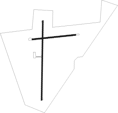
Runway info
Runway 18 / 36  | ||
| length | 1187m (3894ft) | |
| bearing | 187° / 7° | |
| width | 18m (59ft) | |
| surface | asphalt | |
| Runway 08 / 26 | ||
| length | 648m (2126ft) | |
| bearing | 89° / 269° | |
| width | 20m (66ft) | |
| surface | dirt | |
Nearby beacons
| code | identifier | dist | bearing | frequency |
|---|---|---|---|---|
| SWH | SWAN HILL NDB | 45.4 | 183° | 407 |
Disclaimer
The information on this website is not for real aviation. Use this data with the X-Plane flight simulator only! Data taken with kind consent from X-Plane 12 source code and data files. Content is subject to change without notice.