Bundaberg
Airport details
| Country | Australia |
| State | Queensland |
| Region | YB |
| Airspace | Brisbane Ctr |
| Municipality | Bundaberg |
| Elevation | 104ft (32m) |
| Timezone | GMT +10 |
| Coordinates | -24.90068, 152.32127 |
| Magnetic var | |
| Type | land |
| Available since | X-Plane v10.40 |
| ICAO code | YBUD |
| IATA code | BDB |
| FAA code | n/a |
Communication
| Bundaberg CTAF | 126.900 |
Nearby Points of Interest:
Branyan Road State School
-St Andrews Uniting Church, Bundaberg
-Fallon House, Bundaberg
-4BU Radio Station building
-Bundaberg Post Office
-Burnett Bridge
-Kennedy Bridge, Bundaberg
-Saltwater Creek Railway Bridge
-Sir Anthony's Rest
-Isis District War Memorial and Shire Council Chambers
-Paragon Theatre
-Childers Pharmaceutical Museum
-Christ Church, Childers
-Gin Gin railway station
-Howard War Memorial
-Pialba Memorial Cenotaph
-Boolboonda State School
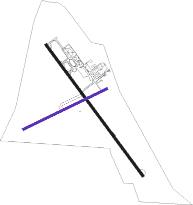
Runway info
Runway 14 / 32  | ||
| length | 2005m (6578ft) | |
| bearing | 145° / 325° | |
| width | 30m (98ft) | |
| surface | asphalt | |
| blast zone | 110m (361ft) / 30m (98ft) | |
| Runway 07 / 25 | ||
| length | 1137m (3730ft) | |
| bearing | 71° / 251° | |
| width | 30m (98ft) | |
| surface | grass | |
| blast zone | 50m (164ft) / 50m (164ft) | |
Nearby beacons
| code | identifier | dist | bearing | frequency |
|---|---|---|---|---|
| BUD | BUNDABERG NDB | 0.3 | 189° | 302 |
Instrument approach procedures
| runway | airway (heading) | route (dist, bearing) |
|---|---|---|
| RW14-Z | BDBNA (124°) | BDBNA 2700ft BDBNI (5mi, 79°) 2700ft |
| RW14-Z | BDBNC (145°) | BDBNC 2700ft BDBNI (5mi, 145°) 2700ft |
| RW14-Z | BDBND (168°) | BDBND 2700ft BDBNI (5mi, 220°) 2700ft |
| RNAV | BDBNI 2700ft BDBNF (5mi, 145°) 1740ft YBUD (5mi, 144°) 150ft BDBNH (3mi, 147°) (8614mi, 279°) 2700ft | |
| RW32-Z | BDBSE (305°) | BDBSE 2700ft BDBSI (5mi, 259°) 2700ft |
| RW32-Z | BDBSG (326°) | BDBSG 2700ft BDBSI (5mi, 325°) 2700ft |
| RW32-Z | BDBSJ (348°) | BDBSJ 2700ft BDBSI (5mi, 40°) 2700ft |
| RNAV | BDBSI 2700ft BDBSF (5mi, 325°) 1740ft YBUD (6mi, 326°) 150ft BDBSH (2mi, 323°) (8615mi, 279°) 2700ft |
Disclaimer
The information on this website is not for real aviation. Use this data with the X-Plane flight simulator only! Data taken with kind consent from X-Plane 12 source code and data files. Content is subject to change without notice.