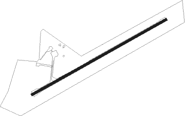
Gayndah
Airport details
| Country | Australia |
| State | Queensland |
| Region | YB |
| Airspace | Brisbane Ctr |
| Municipality | North Burnett Regional |
| Elevation | 368ft (112m) |
| Timezone | GMT +10 |
| Coordinates | -25.61528, 151.62083 |
| Magnetic var | |
| Type | land |
| Available since | X-Plane v10.40 |
| ICAO code | YGAY |
| IATA code | GAH |
| FAA code | n/a |
Communication
| Gayndah GAYNDAH MULT | 126.700 |
| Gayndah ACTIVATE LIGHTS ONLY MULT | 122.400 |
| Gayndah BRISBANE CENTRE MULT | 124.100 |
Nearby Points of Interest:
Brick Cottage, Gayndah
-Gayndah Court House
-Gayndah War Memorial
-Steep Rocky Creek Railway Bridge
-Ideraway Creek Railway Bridge
-Humphery Railway Bridge
-Deep Creek Railway Bridge
-Boolboonda State School
-Boolboonda Tunnel
-Brooweena War Memorial
Runway info
| Runway 06 / 24 | ||
| length | 1266m (4154ft) | |
| bearing | 67° / 247° | |
| width | 20m (66ft) | |
| surface | asphalt | |
Nearby beacons
| code | identifier | dist | bearing | frequency |
|---|---|---|---|---|
| BUD | BUNDABERG NDB | 57 | 45° | 302 |
Instrument approach procedures
| runway | airway (heading) | route (dist, bearing) |
|---|---|---|
| RW06 | GAYWA (47°) | GAYWA 3700ft GAYWI (5mi, 355°) 3610ft |
| RW06 | GAYWB (67°) | GAYWB 3700ft GAYWI (5mi, 67°) 3610ft |
| RW06 | GAYWC (87°) | GAYWC 3700ft GAYWI (5mi, 133°) 3610ft |
| RNAV | GAYWI 3610ft GAYWF (5mi, 67°) 2010ft GAYWM (5mi, 67°) 422ft GAYWH (3mi, 67°) (8561mi, 280°) 3700ft | |
| RWNVE | GAYED (229°) | GAYED 3700ft GAYEI (5mi, 175°) 3700ft |
| RWNVE | GAYEE (247°) | GAYEE 3700ft GAYEI (5mi, 247°) 3700ft |
| RWNVE | GAYEG (265°) | GAYEG 3700ft GAYEI (5mi, 312°) 3700ft |
| RNAV | GAYEI 3700ft GAYEF (5mi, 247°) 2430ft GAYEM (5mi, 247°) 841ft GAYEH (3mi, 247°) (8557mi, 280°) 3100ft |
Disclaimer
The information on this website is not for real aviation. Use this data with the X-Plane flight simulator only! Data taken with kind consent from X-Plane 12 source code and data files. Content is subject to change without notice.
