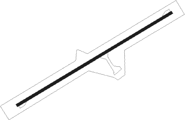
Georgetown
Airport details
| Country | Australia |
| State | Queensland |
| Region | YB |
| Airspace | Brisbane Ctr |
| Municipality | Georgetown |
| Elevation | 995ft (303m) |
| Timezone | GMT +10 |
| Coordinates | -18.30363, 143.53203 |
| Magnetic var | |
| Type | land |
| Available since | X-Plane v10.40 |
| ICAO code | YGTN |
| IATA code | GTT |
| FAA code | n/a |
Communication
| Georgetown CTAF | 126.700 |
Nearby Points of Interest:
Antbed House
-Etheridge railway line
Instrument approach procedures
| runway | airway (heading) | route (dist, bearing) |
|---|---|---|
| RW06-Z | GTNWD (44°) | GTNWD 3800ft GTNWI (5mi, 353°) 3800ft |
| RW06-Z | GTNWE (65°) | GTNWE 3800ft GTNWI (5mi, 65°) 3800ft |
| RW06-Z | GTNWG (86°) | GTNWG 3800ft GTNWI (5mi, 132°) 3800ft |
| RNAV | GTNWI 3800ft GTNWF (5mi, 65°) 2630ft GTNWM (5mi, 65°) 1042ft GTNWH (4mi, 65°) (8398mi, 277°) 3800ft | |
| RW24-Z | GTNEA (223°) | GTNEA 3800ft GTNEI (5mi, 173°) 3800ft |
| RW24-Z | GTNEB (244°) | GTNEB 3800ft GTNEI (5mi, 245°) 3800ft |
| RW24-Z | GTNEC (265°) | GTNEC 3800ft GTNEI (5mi, 312°) 3800ft |
| RNAV | GTNEI 3800ft GTNEF (5mi, 245°) 2610ft GTNEM (5mi, 245°) 1021ft GTNEH (4mi, 245°) (8391mi, 277°) 3800ft |
Disclaimer
The information on this website is not for real aviation. Use this data with the X-Plane flight simulator only! Data taken with kind consent from X-Plane 12 source code and data files. Content is subject to change without notice.
