Holbrook
Airport details
| Country | Australia |
| State | New South Wales |
| Region | YM |
| Airspace | Melbourne Ctr |
| Municipality | Holbrook |
| Elevation | 875ft (267m) |
| Timezone | GMT +11 |
| Coordinates | -35.68333, 147.31667 |
| Magnetic var | |
| Type | land |
| Available since | X-Plane v10.40 |
| ICAO code | YHBK |
| IATA code | n/a |
| FAA code | n/a |
Communication
| Holbrook CTAF | 126.700 |
Nearby Points of Interest:
Henty railway station
-Gerogery railway station
-The Rock railway station
-Bethanga Bridge
-Commercial Hotel, Albury
-Albury Post Office
-New Albury Hotel
-Elm Court, Albury
-Murray River railway bridge
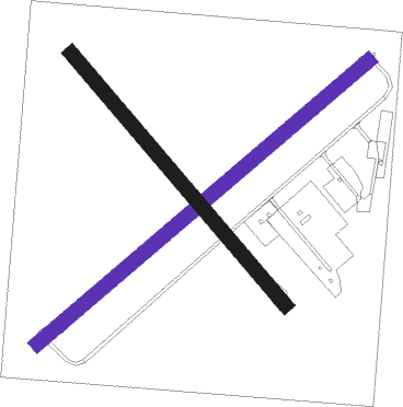
Runway info
| Runway 04 / 22 | ||
| length | 930m (3051ft) | |
| bearing | 59° / 239° | |
| width | 30m (98ft) | |
| surface | dirt | |
Runway 14 / 32  | ||
| length | 704m (2310ft) | |
| bearing | 138° / 318° | |
| width | 30m (98ft) | |
| surface | dirt | |
Nearby beacons
| code | identifier | dist | bearing | frequency |
|---|---|---|---|---|
| AY | ALBURY VOR/DME | 28.7 | 222° | 115.60 |
| WG | WAGGA WAGGA NDB | 31.9 | 15° | 221 |
| COR | COROWA NDB | 50.1 | 252° | 380 |
Disclaimer
The information on this website is not for real aviation. Use this data with the X-Plane flight simulator only! Data taken with kind consent from X-Plane 12 source code and data files. Content is subject to change without notice.