Hamilton
Airport details
| Country | Australia |
| State | Victoria |
| Region | YM |
| Airspace | Melbourne Ctr |
| Municipality | Shire of Southern Grampians |
| Elevation | 800ft (244m) |
| Timezone | GMT +10 |
| Coordinates | -37.64889, 142.06528 |
| Magnetic var | |
| Type | land |
| Available since | X-Plane v10.40 |
| ICAO code | YHML |
| IATA code | HLT |
| FAA code | n/a |
Communication
| Hamilton HAMILTON AERO MULT | 124.200 |
| Hamilton MELBOURNE CENTRE MULT | 125.800 |
| Hamilton ACTIVATE LIGHTS ONLY MULT | 120.600 |
Nearby Points of Interest:
Hamilton Post Office
-Casterton railway station
Runway info
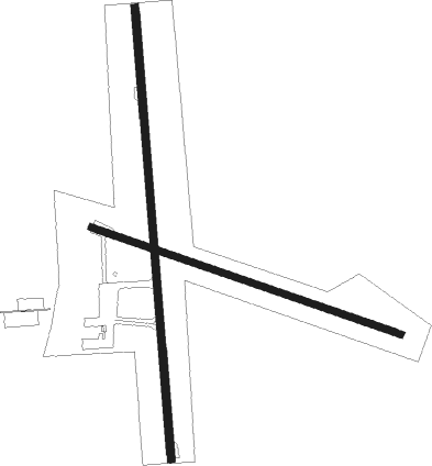
Runway 17 / 35  | ||
| length | 1710m (5610ft) | |
| bearing | 180° / 360° | |
| width | 30m (98ft) | |
| surface | asphalt | |
| Runway 10 / 28 | ||
| length | 1238m (4062ft) | |
| bearing | 109° / 289° | |
| width | 26m (85ft) | |
| surface | dirt | |
Nearby beacons
| code | identifier | dist | bearing | frequency |
|---|---|---|---|---|
| HML | HAMILTON NDB | 0.3 | 267° | 203 |
Instrument approach procedures
| runway | airway (heading) | route (dist, bearing) |
|---|---|---|
| RW17-Z | HLTNJ (154°) | HLTNJ 4800ft HLTNI (5mi, 106°) 3990ft |
| RW17-Z | HLTNK (179°) | HLTNK 4800ft HLTNI (5mi, 180°) 3990ft |
| RW17-Z | HLTNL (205°) | HLTNL 4800ft HLTNI (5mi, 254°) 3990ft |
| RNAV | HLTNI 3990ft HLTNF (5mi, 180°) 2400ft HLTNM (5mi, 180°) 805ft HLTNH (4mi, 168°) (7724mi, 285°) 2700ft | |
| RW35-Z | HLTSE (335°) | HLTSE 4800ft HLTSI (5mi, 286°) 4100ft |
| RW35-Z | HLTSG (1°) | HLTSG 4800ft HLTSI (5mi, 0°) 4100ft |
| RW35-Z | HLTSJ (27°) | HLTSJ 4800ft HLTSI (5mi, 74°) 4100ft |
| RNAV | HLTSI 4100ft HLTSF (5mi, 0°) 2510ft YHML (6mi, 2°) 833ft HLTSH (2mi, 355°) (7727mi, 285°) 4800ft |
Disclaimer
The information on this website is not for real aviation. Use this data with the X-Plane flight simulator only! Data taken with kind consent from X-Plane 12 source code and data files. Content is subject to change without notice.