Morwell - Latrobe Valley
Airport details
| Country | Australia |
| State | Victoria |
| Region | YM |
| Airspace | Melbourne Ctr |
| Municipality | Morwell |
| Elevation | 179ft (55m) |
| Timezone | GMT +11 |
| Coordinates | -38.20722, 146.47028 |
| Magnetic var | |
| Type | land |
| Available since | X-Plane v10.40 |
| ICAO code | YLTV |
| IATA code | TGN |
| FAA code | n/a |
Communication
| Latrobe Valley ACTIVATE LIGHTS ONLY MULTICOM | 122.300 |
| Latrobe Valley LATROBE VALLEY CTAF | 126.000 |
| Latrobe Valley MELBOURNE CENTRE MULTICOM | 124.000 |
Nearby Points of Interest:
Baw Baw National Park
-Thomson River
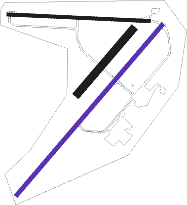
Runway info
Runway 03L / 21R  | ||
| length | 536m (1759ft) | |
| bearing | 52° / 232° | |
| width | 50m (164ft) | |
| surface | grass | |
| Runway 09 / 27 | ||
| length | 902m (2959ft) | |
| bearing | 96° / 276° | |
| width | 23m (75ft) | |
| surface | dirt | |
| Runway 03 / 21 | ||
| length | 1432m (4698ft) | |
| bearing | 52° / 232° | |
| width | 29m (95ft) | |
| surface | asphalt | |
Nearby beacons
| code | identifier | dist | bearing | frequency |
|---|---|---|---|---|
| LTV | LATROBE VALLEY NDB | 0.3 | 50° | 486 |
| ESL | EAST SALE TACAN | 32.9 | 81° | 108.10 |
| ESL | EAST SALE NDB | 33 | 82° | 350 |
Instrument approach procedures
| runway | airway (heading) | route (dist, bearing) |
|---|---|---|
| RW03 | LTVWA (32°) | LTVWA 3900ft LTVWI (5mi, 341°) 3490ft |
| RW03 | LTVWB (51°) | LTVWB 3900ft LTVWI (5mi, 52°) 3490ft |
| RW03 | LTVWC (70°) | LTVWC 3900ft LTVWI (5mi, 110°) 3490ft |
| RNAV | LTVWI 3490ft LTVWF (5mi, 52°) 1890ft YLTV (6mi, 50°) 215ft LTVWH (2mi, 56°) (7865mi, 285°) 3900ft | |
| RW21 | LTVED (207°) | LTVED 6400ft LTVEI (7mi, 150°) 4140ft |
| RW21 | LTVEE (232°) | LTVEE 6400ft LTVEI (7mi, 232°) 4140ft |
| RW21 | LTVEG (254°) | LTVEG 6400ft LTVEI (7mi, 290°) 4140ft |
| RNAV | LTVEI 4140ft LTVEF (6mi, 232°) 2230ft YLTV (7mi, 233°) 230ft LTVEH (2mi, 228°) (7860mi, 285°) 3900ft |
Disclaimer
The information on this website is not for real aviation. Use this data with the X-Plane flight simulator only! Data taken with kind consent from X-Plane 12 source code and data files. Content is subject to change without notice.