Meningie
Airport details
| Country | Australia |
| State | South Australia |
| Region | YM |
| Airspace | Melbourne Ctr |
| Municipality | Meningie |
| Elevation | 13ft (4m) |
| Timezone | GMT +10.5 |
| Coordinates | -35.70175, 139.34459 |
| Magnetic var | |
| Type | land |
| Available since | X-Plane v10.40 |
| ICAO code | YMEG |
| IATA code | n/a |
| FAA code | n/a |
Communication
Nearby Points of Interest:
Lake Alexandrina
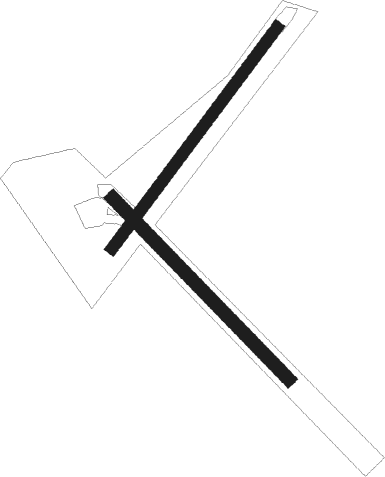
Runway info
Runway 04 / 22  | ||
| length | 949m (3114ft) | |
| bearing | 47° / 227° | |
| width | 40m (131ft) | |
| surface | grass | |
| Runway 14 / 32 | ||
| length | 869m (2851ft) | |
| bearing | 134° / 314° | |
| width | 45m (148ft) | |
| surface | grass | |
Nearby beacons
| code | identifier | dist | bearing | frequency |
|---|---|---|---|---|
| AD | ADELAIDE VOR/DME | 60.5 | 313° | 116.40 |
| PF | PARAFIELD (ADELAIDE) NDB | 64.6 | 322° | 416 |
| EDN | EDINBURGH (ADELAIDE) TACAN | 69.8 | 324° | 110.30 |
Disclaimer
The information on this website is not for real aviation. Use this data with the X-Plane flight simulator only! Data taken with kind consent from X-Plane 12 source code and data files. Content is subject to change without notice.