Nerrin Nerrin
Airport details
| Country | Australia |
| State | Victoria |
| Region | YM |
| Airspace | Melbourne Ctr |
| Municipality | Rural City of Ararat |
| Elevation | 768ft (234m) |
| Timezone | GMT +11 |
| Coordinates | -37.77807, 143.01991 |
| Magnetic var | |
| Type | land |
| Available since | X-Plane v10.40 |
| ICAO code | YNNR |
| IATA code | n/a |
| FAA code | n/a |
Communication
Nearby Points of Interest:
Glenmona Bridge
-Pitfield Bridge
-Aradale Mental Hospital
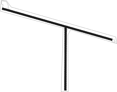
Runway info
Runway 11 / 29  | ||
| length | 884m (2900ft) | |
| bearing | 106° / 286° | |
| width | 15m (49ft) | |
| surface | dirt | |
| Runway 1 / 19 | ||
| length | 495m (1624ft) | |
| bearing | 6° / 186° | |
| width | 15m (49ft) | |
| surface | dirt | |
Nearby beacons
| code | identifier | dist | bearing | frequency |
|---|---|---|---|---|
| HML | HAMILTON NDB | 46.3 | 278° | 203 |
Disclaimer
The information on this website is not for real aviation. Use this data with the X-Plane flight simulator only! Data taken with kind consent from X-Plane 12 source code and data files. Content is subject to change without notice.