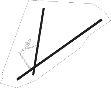
Nyngan
Airport details
| Country | Australia |
| State | New South Wales |
| Region | YM |
| Airspace | Melbourne Ctr |
| Municipality | Nyngan |
| Elevation | 563ft (172m) |
| Timezone | GMT +11 |
| Coordinates | -31.55111, 147.20277 |
| Magnetic var | |
| Type | land |
| Available since | X-Plane v10.40 |
| ICAO code | YNYN |
| IATA code | NYN |
| FAA code | n/a |
Communication
| Nyngan CTAF | 126.700 |
Nearby Points of Interest:
Nyngan Court House

Instrument approach procedures
| runway | airway (heading) | route (dist, bearing) |
|---|---|---|
| RW05-Z | NYNWA (43°) | NYNWA 2400ft NYNWI (5mi, 348°) 2400ft |
| RW05-Z | NYNWB (63°) | NYNWB 2400ft NYNWI (5mi, 63°) 2400ft |
| RW05-Z | NYNWC (82°) | NYNWC 2400ft NYNWI (5mi, 125°) 2400ft |
| RNAV | NYNWI 2400ft NYNWF (5mi, 63°) 2300ft NYNWM (5mi, 63°) 707ft NYNWH (3mi, 63°) (8155mi, 282°) 2200ft | |
| RW23-Z | NYNED (223°) | NYNED 2400ft NYNEI (5mi, 168°) 2400ft |
| RW23-Z | NYNEE (243°) | NYNEE 2400ft NYNEI (5mi, 243°) 2400ft |
| RW23-Z | NYNEG (261°) | NYNEG 2400ft NYNEI (5mi, 305°) 2400ft |
| RNAV | NYNEI 2400ft NYNEF (5mi, 243°) 2290ft NYNEM (5mi, 243°) 705ft NYNEH (3mi, 243°) (8151mi, 282°) 2200ft |
Disclaimer
The information on this website is not for real aviation. Use this data with the X-Plane flight simulator only! Data taken with kind consent from X-Plane 12 source code and data files. Content is subject to change without notice.