Orange
Airport details
| Country | Australia |
| State | New South Wales |
| Region | YM |
| Airspace | Melbourne Ctr |
| Municipality | Orange City Council |
| Elevation | 3108ft (947m) |
| Timezone | GMT +10 |
| Coordinates | -33.37806, 149.12555 |
| Magnetic var | |
| Type | land |
| Available since | X-Plane v10.40 |
| ICAO code | YORG |
| IATA code | OAG |
| FAA code | n/a |
Communication
| Orange ORANGE AWIS | 128.800 |
| Orange ORANGE CTAF | 119.000 |
Nearby Points of Interest:
Bloomfield Hospital
-Grand Western Lodge
-Millthorpe railway station
-Orange Post Office
-Duntryleague with Lodge, Park, Gates and former Stables, Woodward St, Orange, NSW, Australia
-Blayney railway station
-Blayney Uniting Church
-The Saddlery
-Carcoar railway station
-Cliefden Caves
-Georges Plains railway station
-Llanarth (house)
-Bathurst Correctional Complex
-Molong railway station
-Raglan railway station, New South Wales
-Old Bathurst Hospital
-Miss Traill's House
-Abercrombie House
-Bathurst Courthouse
-Bathurst Old School of Arts Library Collection
-Ben Chifley's House
-Royal Hotel, Bathurst
-Bathurst Street Lamps
-Howick Street houses
-Bentinck Street houses, Bathurst
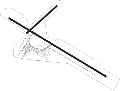
Runway info
Runway 11 / 29  | ||
| length | 2209m (7247ft) | |
| bearing | 121° / 301° | |
| width | 31m (102ft) | |
| surface | asphalt | |
| blast zone | 30m (98ft) / 0m (0ft) | |
| Runway 04 / 22 | ||
| length | 783m (2569ft) | |
| bearing | 57° / 237° | |
| width | 30m (97ft) | |
| surface | grass | |
Nearby beacons
| code | identifier | dist | bearing | frequency |
|---|---|---|---|---|
| BTH | BATHURST NDB | 26.7 | 94° | 383 |
| CWR | COWRA NDB | 36.6 | 225° | 299 |
| PKS | PARKES NDB | 46 | 285° | 242 |
| PKS | PARKES VOR/DME | 47 | 286° | 112 |
| MDG | MUDGEE NDB | 54.7 | 31° | 398 |
Instrument approach procedures
| runway | airway (heading) | route (dist, bearing) |
|---|---|---|
| RW11-Z | OAGWA (104°) | OAGWA 6100ft OAGWI (5mi, 60°) 6100ft |
| RW11-Z | OAGWB (121°) | OAGWB 6100ft OAGWI (5mi, 121°) 6100ft |
| RW11-Z | OAGWC (139°) | OAGWC 6100ft OAGWI (5mi, 198°) 6100ft |
| RNAV | OAGWI 6100ft OAGWF (6mi, 121°) 5060ft YORG (6mi, 121°) 3149ft OAGWH (3mi, 121°) (8155mi, 283°) 5200ft | |
| RW29-Z | OAGED (283°) | OAGED 5200ft OAGEI (5mi, 240°) 5200ft |
| RW29-Z | OAGEE (301°) | OAGEE 5200ft OAGEI (5mi, 301°) 5200ft |
| RW29-Z | OAGEG (321°) | OAGEG 5200ft OAGEI (5mi, 18°) 5200ft |
| RNAV | OAGEI 5200ft OAGEF (5mi, 301°) 4840ft YORG (6mi, 301°) 3162ft OAGEH (4mi, 312°) (8155mi, 283°) 6100ft |
Disclaimer
The information on this website is not for real aviation. Use this data with the X-Plane flight simulator only! Data taken with kind consent from X-Plane 12 source code and data files. Content is subject to change without notice.