Kalgoorlie - Kalgoorlie-boulder
Airport details
| Country | Australia |
| State | Western Australia |
| Region | YM |
| Airspace | Melbourne Ctr |
| Municipality | Kalgoorlie |
| Elevation | 1202ft (366m) |
| Timezone | GMT +8 |
| Coordinates | -30.78944, 121.46167 |
| Magnetic var | |
| Type | land |
| Available since | X-Plane v10.40 |
| ICAO code | YPKG |
| IATA code | KGI |
| FAA code | n/a |
Communication
| Kalgoorlie-Boulder AIR BP UNIC | 126.600 |
| Kalgoorlie-Boulder MELBOURNE CENTRE MULT | 122.100 |
| Kalgoorlie-Boulder ACTIVATE LIGHTS ONLY MULT | 120.600 |
Nearby Points of Interest:
Boulder railway station
-Goldfields Water Supply Scheme
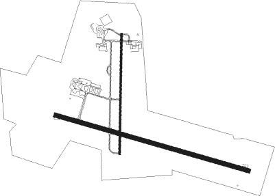
Runway info
Runway 11 / 29  | ||
| length | 1998m (6555ft) | |
| bearing | 108° / 288° | |
| width | 45m (148ft) | |
| surface | asphalt | |
| blast zone | 77m (253ft) / 76m (249ft) | |
| Runway 18 / 36 | ||
| length | 1201m (3940ft) | |
| bearing | 186° / 6° | |
| width | 18m (59ft) | |
| surface | asphalt | |
| displ threshold | 4m (13ft) / 0m (0ft) | |
| blast zone | 76m (249ft) / 76m (249ft) | |
Nearby beacons
| code | identifier | dist | bearing | frequency |
|---|---|---|---|---|
| KG | KALGOORLIE NDB | 0.3 | 164° | 287 |
| KG | KALGOORLIE VOR/DME | 0.4 | 269° | 114.10 |
Instrument approach procedures
| runway | airway (heading) | route (dist, bearing) |
|---|---|---|
| RW11-U | IDGIB (107°) | IDGIB 3100ft KG904 (turn) 2830ft |
| RW11-U | PARKU (79°) | PARKU 4200ft KG908 (3mi, 45°) 4200ft KG904 (4mi, 62°) 2830ft |
| RNAV | KG904 2830ft YPKG (6mi, 107°) 1251ft LADEP (7mi, 108°) 3100ft | |
| RW11-Z | PKGWA (89°) | PKGWA 3100ft PKGWI (5mi, 45°) 3100ft |
| RW11-Z | PKGWB (108°) | PKGWB 3100ft PKGWI (5mi, 108°) 3100ft |
| RW11-Z | PKGWC (127°) | PKGWC 3100ft PKGWI (5mi, 181°) 3100ft |
| RNAV | PKGWI 3100ft PKGWF (5mi, 108°) 2930ft PKGWM (5mi, 108°) 1339ft PKGWH (3mi, 108°) (7007mi, 284°) 3100ft | |
| RW18-Z | PKGND (162°) | PKGND 3100ft PKGNI (5mi, 112°) 3100ft |
| RW18-Z | PKGNE (186°) | PKGNE 3100ft PKGNI (5mi, 186°) 3100ft |
| RW18-Z | PKGNG (209°) | PKGNG 3100ft PKGNI (5mi, 257°) 3100ft |
| RNAV | PKGNI 3100ft PKGNF (5mi, 186°) 2890ft PKGNM (5mi, 186°) 1302ft PKGNH (3mi, 186°) (7004mi, 284°) 3100ft | |
| RW29-U | LADEP (288°) | LADEP 3100ft KG902 (turn) 2800ft |
| RW29-U | PARKU (79°) | PARKU 7000ft KG914 (3mi, 96°) 7000ft KG912 (12mi, 113°) 5800ft KG902 (6mi, 26°) 2800ft |
| RW29-U | RUNIV (107°) | RUNIV 6500ft KG920 (5mi, 123°) 6500ft KG916 (8mi, 138°) 5800ft KG912 (2mi, 125°) 5800ft KG902 (6mi, 26°) 2800ft |
| RNAV | KG902 2800ft YPKG (6mi, 288°) 1195ft IDGIB (7mi, 287°) 3100ft | |
| RW29-Z | PKGEJ (270°) | PKGEJ 3100ft PKGEI (5mi, 225°) 3100ft |
| RW29-Z | PKGEK (288°) | PKGEK 3100ft PKGEI (5mi, 288°) 3100ft |
| RW29-Z | PKGEL (307°) | PKGEL 3100ft PKGEI (5mi, 1°) 3100ft |
| RNAV | PKGEI 3100ft PKGEF (5mi, 288°) 2870ft PKGEM (5mi, 288°) 1283ft PKGEH (3mi, 288°) (7003mi, 284°) 3100ft | |
| RW36-Z | PKGSN (342°) | PKGSN 3100ft PKGSI (5mi, 292°) 3100ft |
| RW36-Z | PKGSO (6°) | PKGSO 3100ft PKGSI (5mi, 6°) 3100ft |
| RW36-Z | PKGSP (30°) | PKGSP 3100ft PKGSI (5mi, 77°) 3100ft |
| RNAV | PKGSI 3100ft PKGSF (5mi, 6°) 2920ft PKGSM (5mi, 6°) 1323ft PKGSH (3mi, 323°) (7004mi, 284°) 3100ft |
Disclaimer
The information on this website is not for real aviation. Use this data with the X-Plane flight simulator only! Data taken with kind consent from X-Plane 12 source code and data files. Content is subject to change without notice.