Port Lincoln
Airport details
| Country | Australia |
| State | South Australia |
| Region | YM |
| Airspace | Melbourne Ctr |
| Municipality | The District Council of Lower Eyre Penin |
| Elevation | 35ft (11m) |
| Timezone | GMT +9.5 |
| Coordinates | -34.60279, 135.87587 |
| Magnetic var | |
| Type | land |
| Available since | X-Plane v10.40 |
| ICAO code | YPLC |
| IATA code | PLO |
| FAA code | n/a |
Communication
| Port Lincoln CTAF | 128.000 |
Runway info
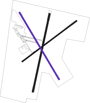
Runway 01 / 19  | ||
| length | 1501m (4925ft) | |
| bearing | 20° / 200° | |
| width | 30m (98ft) | |
| surface | asphalt | |
| Runway 05 / 23 | ||
| length | 1273m (4177ft) | |
| bearing | 62° / 242° | |
| width | 25m (82ft) | |
| surface | dirt | |
| Runway 15 / 33 | ||
| length | 1460m (4790ft) | |
| bearing | 149° / 329° | |
| width | 30m (98ft) | |
| surface | dirt | |
Nearby beacons
| code | identifier | dist | bearing | frequency |
|---|---|---|---|---|
| PLC | PORT LINCOLN NDB | 0.1 | 238° | 389 |
Instrument approach procedures
| runway | airway (heading) | route (dist, bearing) |
|---|---|---|
| RW19-Z | PLZNA (188°) | PLZNA 3600ft PLZNI (5mi, 131°) 3540ft |
| RW19-Z | PLZNC (211°) | PLZNC 3600ft PLZNI (5mi, 211°) 3540ft |
| RW19-Z | PLZND (232°) | PLZND 3600ft PLZNI (5mi, 275°) 3540ft |
| RNAV | PLZNI 3540ft PLZNF (5mi, 211°) 1950ft PLZNM (5mi, 211°) 356ft PLZNH (3mi, 211°) (7579mi, 284°) 2600ft |
Disclaimer
The information on this website is not for real aviation. Use this data with the X-Plane flight simulator only! Data taken with kind consent from X-Plane 12 source code and data files. Content is subject to change without notice.