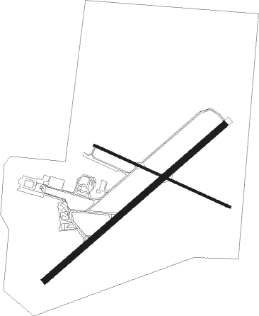
Dubbo
Airport details
| Country | Australia |
| State | New South Wales |
| Region | YM |
| Airspace | Melbourne Ctr |
| Municipality | Dubbo |
| Elevation | 935ft (285m) |
| Timezone | GMT +10 |
| Coordinates | -32.21667, 148.57472 |
| Magnetic var | |
| Type | land |
| Available since | X-Plane v10.40 |
| ICAO code | YSDU |
| IATA code | DBO |
| FAA code | n/a |
Communication
| Dubbo DUBBO AWIS | 122.975 |
| Dubbo DUBBO CTAF | 134.000 |
| Dubbo MELBOURNE CENTRE MULT | 123.900 |
Nearby Points of Interest:
Macquarie River Railway Bridge, Dubbo
-Colonial Mutual Life building, Dubbo
-Dubbo RAAF Stores Depot
-Wellington Post Office
-St Ambrose Church, Gilgandra

Nearby beacons
| code | identifier | dist | bearing | frequency |
|---|---|---|---|---|
| DU | DUBBO NDB | 0.7 | 267° | 251 |
| PKS | PARKES VOR/DME | 57.5 | 200° | 112 |
| PKS | PARKES NDB | 58 | 199° | 242 |
Instrument approach procedures
| runway | airway (heading) | route (dist, bearing) |
|---|---|---|
| RW05 | DBOWD (37°) | DBOWD 4100ft DBOWI (5mi, 341°) 4100ft |
| RW05 | DBOWE (58°) | DBOWE 4100ft DBOWI (5mi, 58°) 4100ft |
| RW05 | DBOWG (76°) | DBOWG 4100ft DBOWI (5mi, 120°) 4100ft |
| RNAV | DBOWI 4100ft DBOWF (5mi, 58°) 2660ft YSDU (6mi, 57°) 985ft DBOWH (3mi, 61°) (8183mi, 282°) 3700ft | |
| RW23 | DBOEA (219°) | DBOEA 3700ft DBOEI (5mi, 161°) 3700ft |
| RW23 | DBOEB (238°) | DBOEB 3700ft DBOEI (5mi, 238°) 3700ft |
| RW23 | DBOEC (256°) | DBOEC 3700ft DBOEI (5mi, 299°) 3700ft |
| RNAV | DBOEI 3700ft DBOEF (5mi, 238°) 2800ft YSDU (6mi, 239°) 953ft DBOEH (3mi, 235°) (8178mi, 282°) 3700ft |
Disclaimer
The information on this website is not for real aviation. Use this data with the X-Plane flight simulator only! Data taken with kind consent from X-Plane 12 source code and data files. Content is subject to change without notice.