Burnt Pine - Norfolk Island Intl
Airport details
| Country | Australia |
| State | [Other] |
| Region | YB |
| Municipality | Norfolk Island |
| Elevation | 371ft (113m) |
| Timezone | GMT +11 |
| Coordinates | -29.04258, 167.93806 |
| Magnetic var | |
| Type | land |
| Available since | X-Plane v10.40 |
| ICAO code | YSNF |
| IATA code | NLK |
| FAA code | n/a |
Communication
| Norfolk Island Intl CTAF | 118.100 |
Nearby Points of Interest:
Kingston and Arthurs Vale Historic Area
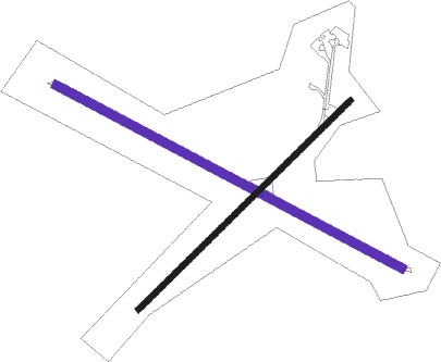
Runway info
| Runway 11 / 29 | ||
| length | 1892m (6207ft) | |
| bearing | 119° / 299° | |
| width | 45m (148ft) | |
| surface | asphalt | |
| blast zone | 57m (187ft) / 57m (187ft) | |
Runway 04 / 22  | ||
| length | 1439m (4721ft) | |
| bearing | 54° / 234° | |
| width | 30m (98ft) | |
| surface | asphalt | |
| blast zone | 115m (377ft) / 0m (0ft) | |
Nearby beacons
| code | identifier | dist | bearing | frequency |
|---|---|---|---|---|
| NF | NORFOLK I VOR/DME | 0.4 | 231° | 112.40 |
| NF | NORFOLK I NDB | 2.3 | 334° | 260 |
Instrument approach procedures
| runway | airway (heading) | route (dist, bearing) |
|---|---|---|
| RW11-X | ABVOM (322°) | ABVOM AMSTA (15mi, 301°) 3300ft BECKY (11mi, 299°) 3300ft NF261 (6mi, 347°) 2000ft SAMOT (6mi, 80°) 2000ft |
| RW11-X | DALOS (92°) | DALOS REEZA (12mi, 69°) 2300ft PINKY (3mi, 93°) 2000ft SAMOT (4mi, 119°) 2000ft |
| RNAV | SAMOT 2000ft YSNF (6mi, 120°) 371ft DEZZI (1mi, 116°) (8934mi, 280°) 2300ft | |
| RW29-X | ABVOM (322°) | ABVOM ARCHA (9mi, 341°) 2300ft SIRUS (5mi, 339°) 2000ft BOODA (4mi, 299°) 2000ft |
| RW29-X | DALOS (92°) | DALOS BECKY (14mi, 107°) 3300ft AMSTA (11mi, 119°) 3300ft NF131 (6mi, 80°) 2000ft BOODA (6mi, 347°) 2000ft |
| RNAV | BOODA 2000ft YSNF (5mi, 298°) 416ft MUMSY (2mi, 301°) (8934mi, 280°) 2300ft |
Disclaimer
The information on this website is not for real aviation. Use this data with the X-Plane flight simulator only! Data taken with kind consent from X-Plane 12 source code and data files. Content is subject to change without notice.