Wellington
Airport details
| Country | Australia |
| State | New South Wales |
| Region | YB |
| Airspace | Melbourne Ctr |
| Municipality | Dubbo Regional Council |
| Elevation | 1396ft (426m) |
| Timezone | GMT +11 |
| Coordinates | -32.46250, 148.99055 |
| Magnetic var | |
| Type | land |
| Available since | X-Plane v10.40 |
| ICAO code | YWEL |
| IATA code | n/a |
| FAA code | n/a |
Communication
| Wellington CTAF | 126.700 |
Nearby Points of Interest:
Wellington Post Office
-Stuart Town railway station
-Dubbo RAAF Stores Depot
-Colonial Mutual Life building, Dubbo
-Macquarie River Railway Bridge, Dubbo
-Gulgong railway bridge over Wialdra Creek
-Mudgee railway station
-St. Mary's Roman Catholic Church, Presbytery, Convent & Hall
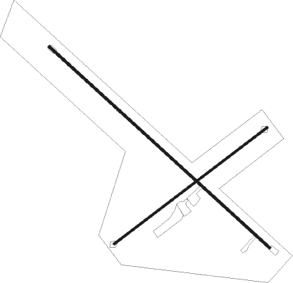
Runway info
Runway 13 / 31  | ||
| length | 1496m (4908ft) | |
| bearing | 132° / 312° | |
| width | 15m (49ft) | |
| surface | asphalt | |
| Runway 05 / 23 | ||
| length | 962m (3156ft) | |
| bearing | 61° / 241° | |
| width | 10m (33ft) | |
| surface | gravel | |
Nearby beacons
| code | identifier | dist | bearing | frequency |
|---|---|---|---|---|
| DU | DUBBO NDB | 26.3 | 300° | 251 |
| MDG | MUDGEE NDB | 32.2 | 99° | 398 |
| PKS | PARKES NDB | 55.3 | 227° | 242 |
| BTH | BATHURST NDB | 66.2 | 145° | 383 |
Disclaimer
The information on this website is not for real aviation. Use this data with the X-Plane flight simulator only! Data taken with kind consent from X-Plane 12 source code and data files. Content is subject to change without notice.