Albion Park - Shellharbour
Airport details
| Country | Australia |
| State | New South Wales |
| Region | YM |
| Airspace | Melbourne Ctr |
| Municipality | Shellharbour City Council |
| Elevation | 34ft (10m) |
| Timezone | GMT +10 |
| Coordinates | -34.55973, 150.78940 |
| Magnetic var | |
| Type | land |
| Available since | X-Plane v10.40 |
| ICAO code | YWOL |
| IATA code | WOL |
| FAA code | n/a |
Communication
| Shellharbour CTAF | 127.300 |
Nearby Points of Interest:
Dunmore railway station
-St Stephen's Presbyterian Church, Jamberoo
-Bombo railway station
-Kiama railway station
-Kiama Masonic Temple
-Wollongong railway station
-Upper Nepean Scheme
-Nepean Dam
-Mittagong railway station
-Bomaderry Aboriginal Children's Home
-Graham Lodge
-Moss Vale railway station
-Stanwell Park Rail Viaduct over Stanwell Creek
-Bargo railway viaduct
-Mount Broughton
-Berrima Correctional Centre
-Picton railway station
-Stonequarry Creek railway viaduct, Picton
-Beulah
-Menangle Railway Bridge
-Camden Park Estate
-MV Lady Denman
-St John's Catholic Church, Campbelltown
-Dredges Cottage
-Campbelltown Post Office
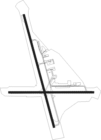
Runway info
Runway 16 / 34  | ||
| length | 1824m (5984ft) | |
| bearing | 167° / 347° | |
| width | 30m (98ft) | |
| surface | asphalt | |
| displ threshold | 0m (0ft) / 179m (587ft) | |
| Runway 08 / 26 | ||
| length | 1332m (4370ft) | |
| bearing | 94° / 274° | |
| width | 30m (98ft) | |
| surface | asphalt | |
| displ threshold | 0m (0ft) / 84m (276ft) | |
| blast zone | 22m (72ft) / 16m (52ft) | |
Nearby beacons
| code | identifier | dist | bearing | frequency |
|---|---|---|---|---|
| WOL | WOLLONGONG NDB | 0.1 | 41° | 239 |
| NWA | NOWRA TACAN | 26.6 | 213° | 116.40 |
| NWA | NOWRA NDB | 26.7 | 214° | 359 |
| BK | BANKSTOWN (SYDNEY) NDB | 39.1 | 18° | 416 |
| SY | DME | 41.8 | 33° | 112.10 |
| RIC | RICHMOND TACAN | 57.2 | 1° | 110.70 |
| RIC | RICHMOND NDB | 57.8 | 359° | 347 |
Disclaimer
The information on this website is not for real aviation. Use this data with the X-Plane flight simulator only! Data taken with kind consent from X-Plane 12 source code and data files. Content is subject to change without notice.