Beijing - Beijing Daxing Intl
Airport details
| Country | China |
| State | Beijing |
| Region | ZB |
| Airspace | Beijing Ctr |
| Municipality | Daxing District |
| Elevation | 82ft (25m) |
| Timezone | GMT +8 |
| Coordinates | 39.50000, 116.40000 |
| Magnetic var | |
| Type | land |
| Available since | X-Plane v11.50 |
| ICAO code | ZBAD |
| IATA code | PKX |
| FAA code | n/a |
Communication
| Beijing Daxing Intl ATIS | 128.400 |
| Beijing Daxing Intl BEIJING Ground Control | 121.625 |
| Beijing Daxing Intl BEIJING Tower | 118.375 |
| Beijing Daxing Intl BEIJING Approach | 124.700 |
Approach frequencies
| ILS-cat-III | RW01L | 110.55 | 18.00mi |
| ILS-cat-II | RW35L | 111.9 | 18.00mi |
| ILS-cat-I | RW17L | 110.75 | 18.00mi |
| ILS-cat-I | RW19R | 110.55 | 18.00mi |
| ILS-cat-I | RW17R | 111.9 | 18.00mi |
| ILS-cat-I | RW35R | 110.75 | 18.00mi |
| ILS-cat-I | RW29R | 108.7 | 18.00mi |
| 3° GS | RW35L | 111.9 | 18.00mi |
| 3° GS | RW35R | 110.75 | 18.00mi |
| 3° GS | RW17R | 111.9 | 18.00mi |
| 3° GS | RW17L | 110.75 | 18.00mi |
| 3° GS | RW19R | 110.55 | 18.00mi |
| 3° GS | RW01L | 110.55 | 18.00mi |
| 3° GS | RW29R | 108.7 | 18.00mi |
Nearby Points of Interest:
Western Zhou Yan State Capital Museum
-Haotian Pagoda
-Asbury Church
-St. Michael's Church
-Southeast Corner Tower
-Li Dazhao Former Residence
-Beijing Shejitan
-Zhongnanhai
-Temple of the Moon
-Pagoda of Monk Wansong
-Guangji Temple
-Temple of Ancient Monarchs
-Prince Fu Mansion
-Miaoying Temple
-Zhalan Cemetery
-Former site of the Army and Navy Department of Qing Dynasty
-Home of Guomoruo
-Pagoda of Cishou Temple
-Ancestral Temple for Wen Tianxiang
-Guanghua Temple
-Jietai Temple
-Dahui Temple
Runway info
Runway 11L / 29R  | ||
| length | 3808m (12493ft) | |
| bearing | 100° / 280° | |
| width | 60m (197ft) | |
| surface | concrete | |
| displ threshold | 0m (0ft) / 7m (23ft) | |
| Runway 17L / 35R | ||
| length | 3807m (12490ft) | |
| bearing | 171° / 351° | |
| width | 60m (197ft) | |
| surface | concrete | |
| Runway 01L / 19R | ||
| length | 3407m (11178ft) | |
| bearing | 351° / 171° | |
| width | 60m (197ft) | |
| surface | concrete | |
| Runway 17R / 35L | ||
| length | 3807m (12490ft) | |
| bearing | 171° / 351° | |
| width | 45m (148ft) | |
| surface | concrete | |
Airport layout
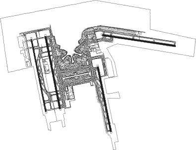
Taxiway locations
|
Parking locations
|
Nearby beacons
| code | identifier | dist | bearing | frequency |
|---|---|---|---|---|
| DXG | DAXING VOR/DME | 1.5 | 192° | 115.35 |
| JR | LIANGXIANG NDB | 19.3 | 306° | 475 |
| VYK | DAWANGZHUANG VOR/DME | 19.9 | 151° | 112.70 |
| VM | SHIGEZHUANG NDB | 26.2 | 112° | 280 |
| JB | ZANGANGZHEN NDB | 28.9 | 204° | 403 |
| QU | BEIJING CAPITAL NDB | 31.1 | 23° | 240 |
| DK | BEIJING CAPITAL NDB | 33.2 | 19° | 354 |
| WF | XILIUHETUN NDB | 34.5 | 47° | 395 |
| PEK | GUANZHUANG VOR/DME | 36.3 | 31° | 114.70 |
| SZY | SHAZIYING VOR/DME | 36.4 | 3° | 117.20 |
| CU | SHAHE NDB | 37.3 | 357° | 555 |
| OR | BEIJING CAPITAL NDB | 38.3 | 17° | 196 |
| CD | QINGBAIKOU NDB | 41.2 | 311° | 422 |
| OB | HUAIROU NDB | 47.7 | 10° | 380 |
| TAJ | TIANJIN VOR/DME | 50.2 | 112° | 112.10 |
| CG | TIANJIN NDB | 51.8 | 113° | 339 |
| HUR | HUAIROU VOR/DME | 52.3 | 23° | 113.60 |
| KM | HUAILAI NDB | 67.6 | 315° | 360 |
Departure and arrival routes
| Transition altitude | 9850ft |
| Transition level | 118ft |
| SID end points | distance | outbound heading | |
|---|---|---|---|
| RW01L | |||
| IDK02D | 77mi | 7° | |
| DOT02D | 78mi | 18° | |
| MUG02D | 80mi | 105° | |
| ELK02D | 53mi | 163° | |
| RW11L | |||
| IDK01D | 77mi | 7° | |
| DOT01D | 78mi | 18° | |
| MUG01D | 80mi | 105° | |
| ELK01D | 53mi | 163° | |
| RW17L | |||
| OMD11D | 53mi | 200° | |
| PEG11D | 53mi | 238° | |
| RW17R | |||
| OMD12D | 53mi | 200° | |
| PEG12D | 53mi | 238° | |
| RW19R | |||
| IDK11D | 77mi | 7° | |
| DOT11D | 78mi | 18° | |
| MUG11D | 80mi | 105° | |
| ELK11D | 53mi | 163° | |
| RW35L | |||
| OMD02D | 53mi | 200° | |
| PEG02D | 53mi | 238° | |
| RW35R | |||
| OMD01D | 53mi | 200° | |
| PEG01D | 53mi | 238° | |
| STAR starting points | distance | inbound heading | |
|---|---|---|---|
| RW01L | |||
| AVB02A | 51.1 | 1° | |
| BEL01A | 38.9 | 36° | |
| ELA01A | 17.8 | 45° | |
| DUM01A | 27.2 | 317° | |
| BUM01A | 17.2 | 320° | |
| RW17 (ALL) | |||
| BEL11A, ELA11A | 21.4 | 130° | |
| RW19R | |||
| ELA11A, BEL11A | 21.4 | 130° | |
| RW35 (ALL) | |||
| BEL01A | 38.9 | 36° | |
| ELA01A | 17.8 | 45° | |
| DUM01A | 27.2 | 317° | |
| BUM01A | 17.2 | 320° | |
| RW35L | |||
| AVB02A | 51.1 | 1° | |
| RW35R | |||
| AVB01A | 51.1 | 1° | |
Holding patterns
| STAR name | hold at | type | turn | heading* | altitude | leg | speed limit |
|---|---|---|---|---|---|---|---|
| AVB01A | AVBOX | VHF | left | 199 (19)° | > 11800ft | 1.0min timed | ICAO rules |
| AVB02A | AVBOX | VHF | left | 199 (19)° | > 11800ft | 1.0min timed | ICAO rules |
| AVB11A | AD646 | VHF | right | 179 (359)° | > 2960ft | 1.0min timed | 230 |
| AVB11A | AVBOX | VHF | left | 199 (19)° | > 11800ft | 1.0min timed | ICAO rules |
| BEL01A | BELAX | VHF | left | 252 (72)° | > 11800ft | 1.0min timed | ICAO rules |
| BEL11A | AD768 | VHF | right | 179 (359)° | > 2960ft | 1.0min timed | 230 |
| BEL11A | BELAX | VHF | left | 252 (72)° | > 11800ft | 1.0min timed | ICAO rules |
| BUM01A | AD646 | VHF | right | 179 (359)° | > 2960ft | 1.0min timed | 230 |
| BUM01A | BUMDU | VHF | right | 27 (207)° | > 15700ft | 1.5min timed | ICAO rules |
| BUM11A | BUMDU | VHF | right | 27 (207)° | > 15700ft | 1.5min timed | ICAO rules |
| DUM11A | AD646 | VHF | right | 179 (359)° | > 2960ft | 1.0min timed | 230 |
| ELA01A | AD768 | VHF | right | 179 (359)° | > 2960ft | 1.0min timed | 230 |
| ELA01A | ELAPU | VHF | right | 281 (101)° | > 12800ft | 1.0min timed | ICAO rules |
| ELA11A | ELAPU | VHF | right | 281 (101)° | > 12800ft | 1.0min timed | ICAO rules |
| *) magnetic outbound (inbound) holding course | |||||||
Disclaimer
The information on this website is not for real aviation. Use this data with the X-Plane flight simulator only! Data taken with kind consent from X-Plane 12 source code and data files. Content is subject to change without notice.