Shijiazhuang - Shijiazhuang/zhengding
Airport details
| Country | China |
| State | Hebei |
| Region | ZB |
| Airspace | Beijing Ctr |
| Municipality | Shijiazhuang City |
| Elevation | 229ft (70m) |
| Timezone | GMT +8 |
| Coordinates | 38.28167, 114.69833 |
| Magnetic var | |
| Type | land |
| Available since | X-Plane v10.40 |
| ICAO code | ZBSJ |
| IATA code | SJW |
| FAA code | ZBSJ |
Communication
| Shijiazhuang/Zhengding Zhengding ATIS | 127.850 |
| Shijiazhuang/Zhengding Departure02 | 119.125 |
| Shijiazhuang/Zhengding Zhengding Tower | 118.350 |
| Shijiazhuang/Zhengding Zhengding Ground | 121.600 |
| Shijiazhuang/Zhengding Approach01 | 120.450 |
| Shijiazhuang/Zhengding Approach02 | 119.125 |
| Shijiazhuang/Zhengding Departure01 | 120.450 |
Approach frequencies
| ILS-cat-I | RW33 | 110.3 | 18.00mi |
| ILS-cat-I | RW15 | 109.9 | 18.00mi |
| 3° GS | RW33 | 110.3 | 18.00mi |
| 3° GS | RW15 | 109.9 | 18.00mi |
Nearby Points of Interest:
Zhengding Town
-Zhengding Prefectural Temple of Literature
-Stele of the Ode to the Feat of the Prince Qinghe
-Kaiyuan Temple (Zhengding)
Runway info
| Runway 15 / 33 | ||
| length | 3406m (11175ft) | |
| bearing | 141° / 321° | |
| width | 45m (148ft) | |
| surface | concrete | |
| blast zone | 58m (190ft) / 61m (200ft) | |
Airport layout
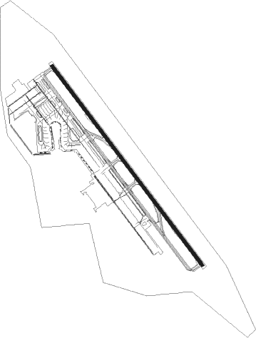
Taxiway locations
Parking locations
|
Nearby beacons
| code | identifier | dist | bearing | frequency |
|---|---|---|---|---|
| SJW | ZHENGDING VOR/DME | 0.1 | 180° | 117.70 |
| O | ZHENGDING (SHIJIAZHUANG) NDB | 1.4 | 318° | 528 |
| F | ZHENGDING (SHIJIAZHUANG) NDB | 1.5 | 144° | 377 |
| FL | WUJI NDB | 9.1 | 100° | 272 |
| OC | XINGTANG NDB | 12.4 | 320° | 235 |
Departure and arrival routes
| Transition altitude | 9842ft |
| Transition level | 11811ft |
| SID end points | distance | outbound heading | |
|---|---|---|---|
| RW15 | |||
| BEL01D, BEL9ZD | 47mi | 62° | |
| UKM9ZD, UKM03D, UKM01D | 36mi | 103° | |
| ADB9ZD, ADB01D | 32mi | 282° | |
| VAD01D, VAD9ZD | 49mi | 339° | |
| RW33 | |||
| BEL8ZD, BEL02D | 47mi | 62° | |
| UKM02D, UKM04D, UKM8ZD | 36mi | 103° | |
| ADB8ZD, ADB02D | 32mi | 282° | |
| VAD02D, VAD8ZD | 49mi | 339° | |
| STAR starting points | distance | inbound heading | |
|---|---|---|---|
| RW15 | |||
| TON9ZA, TON01A | 28.4 | 81° | |
| VAD01A, VAD9ZA | 49.2 | 159° | |
| PEG01A, PEG9ZA | 54.9 | 231° | |
| LIK01A, LIK03A, LIK9ZA, LIK9YA | 39.8 | 293° | |
| AVL01A, AVL9ZA, AVL9YA | 51.8 | 330° | |
| RW33 | |||
| TON02A, TON8ZA | 28.4 | 81° | |
| VAD02A, VAD8ZA | 49.2 | 159° | |
| PEG8ZA, PEG04A, PEG02A | 54.9 | 231° | |
| LIK04A, LIK8ZA, LIK8YA, LIK02A | 39.8 | 293° | |
| AVL02A, AVL8YA, AVL8ZA | 51.8 | 330° | |
Holding patterns
| STAR name | hold at | type | turn | heading* | altitude | leg | speed limit |
|---|---|---|---|---|---|---|---|
| AVL8ZA | FL | FIX | right | 17 (197)° | > 3940ft | 1.0min timed | 230 |
| AVL9ZA | OC | FIX | left | 332 (152)° | > 4930ft | 1.0min timed | 230 |
| LIK01A | FL | FIX | right | 17 (197)° | > 3940ft | 1.0min timed | 230 |
| LIK02A | FL | FIX | right | 17 (197)° | > 3940ft | 1.0min timed | 230 |
| LIK8ZA | FL | FIX | right | 17 (197)° | > 3940ft | 1.0min timed | 230 |
| LIK9ZA | OC | FIX | left | 332 (152)° | > 4930ft | 1.0min timed | 230 |
| PEG01A | OC | FIX | left | 332 (152)° | > 4930ft | 1.0min timed | 230 |
| PEG02A | OC | FIX | left | 332 (152)° | > 4930ft | 1.0min timed | 230 |
| PEG04A | FL | FIX | right | 17 (197)° | > 3940ft | 1.0min timed | 230 |
| PEG8ZA | FL | FIX | right | 17 (197)° | > 3940ft | 1.0min timed | 230 |
| PEG9ZA | OC | FIX | left | 332 (152)° | > 4930ft | 1.0min timed | 230 |
| TON01A | OC | FIX | left | 332 (152)° | > 4930ft | 1.0min timed | 230 |
| TON02A | OC | FIX | left | 332 (152)° | > 4930ft | 1.0min timed | 230 |
| TON8ZA | FL | FIX | right | 17 (197)° | > 3940ft | 1.0min timed | 230 |
| TON9ZA | OC | FIX | left | 332 (152)° | > 4930ft | 1.0min timed | 230 |
| VAD01A | OC | FIX | left | 332 (152)° | > 4930ft | 1.0min timed | 230 |
| VAD02A | OC | FIX | left | 332 (152)° | > 4930ft | 1.0min timed | 230 |
| VAD8ZA | FL | FIX | right | 17 (197)° | > 3940ft | 1.0min timed | 230 |
| VAD9ZA | OC | FIX | left | 332 (152)° | > 4930ft | 1.0min timed | 230 |
| *) magnetic outbound (inbound) holding course | |||||||
Disclaimer
The information on this website is not for real aviation. Use this data with the X-Plane flight simulator only! Data taken with kind consent from X-Plane 12 source code and data files. Content is subject to change without notice.