Amoy - Amoy Gaoqi Intl
Airport details
| Country | China |
| State | Fujian |
| Region | ZS |
| Airspace | Shanghai Ctr |
| Municipality | Huli District |
| Elevation | 59ft (18m) |
| Timezone | GMT +8 |
| Coordinates | 24.54500, 118.12666 |
| Magnetic var | |
| Type | land |
| Available since | X-Plane v10.32 |
| ICAO code | ZSAM |
| IATA code | XMN |
| FAA code | n/a |
Communication
| Amoy Gaoqi Intl ATIS | 126.250 |
| Amoy Gaoqi Intl Xiamen Delivery | 121.950 |
| Amoy Gaoqi Intl Xiamen Ground | 121.700 |
| Amoy Gaoqi Intl Xiamen Apron 01 | 121.800 |
| Amoy Gaoqi Intl Xiamen Apron 02 | 121.600 |
| Amoy Gaoqi Intl Xiamen Tower | 118.250 |
| Amoy Gaoqi Intl Xiamen Approach 02 | 120.200 |
| Amoy Gaoqi Intl Xiamen Approach 03 | 123.825 |
| Amoy Gaoqi Intl Xiamen Approach 04 | 125.025 |
| Amoy Gaoqi Intl Xiamen Approach 01 | 121.350 |
Approach frequencies
| ILS-cat-I | RW23 | 109.7 | 18.00mi |
| ILS-cat-I | RW05 | 110.3 | 18.00mi |
| 3° GS | RW23 | 109.7 | 18.00mi |
| 3° GS | RW05 | 110.3 | 18.00mi |
Nearby Points of Interest:
Kah Kee Park
-Tomb of Chen Huacheng
-Beishan Old Western-style House
-Gulongtou Zhenwei Residence
-Zheng Chenggong's Tomb
-Jiangdong Bridge
-Zhangzhou Stone Arch
-Zhangzhou Lin Ancestral Hall
-Anxi Confucian Temple
-Lingshan Islamic Cemetery
-Liusheng Pagoda
Runway info
| Runway 05 / 23 | ||
| length | 3403m (11165ft) | |
| bearing | 54° / 234° | |
| width | 45m (148ft) | |
| surface | asphalt | |
| displ threshold | 150m (492ft) / 200m (656ft) | |
| blast zone | 40m (131ft) / 60m (197ft) | |
Airport layout
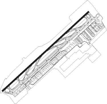
Taxiway locations
Parking locations
|
Nearby beacons
| code | identifier | dist | bearing | frequency |
|---|---|---|---|---|
| XMN | XIAMEN VOR/DME | 0.2 | 243° | 114.50 |
| XLN | XINGLIN VOR/DME | 6.2 | 280° | 114.70 |
| BS | KINMEN NDB | 14 | 118° | 345 |
| KIN | CHIN MEN TACAN | 14 | 118° | 109.20 |
| D | JINJIANG NDB | 28.4 | 63° | 405 |
| JNJ | JINJIANG VOR/DME | 29.9 | 61° | 117 |
| O | JINJIANG (QUANZHOU) NDB | 30.4 | 60° | 438 |
| OJ | JINJIANG NDB | 33.4 | 58° | 212 |
Departure and arrival routes
| Transition altitude | 9842ft |
| Transition level | 11811ft |
| SID end points | distance | outbound heading | |
|---|---|---|---|
| RW05 | |||
| FQG01D, FQG91D, FQG92D, FQG93D | 99mi | 46° | |
| NUS92D, NUS91D, NUS01D | 40mi | 225° | |
| TEB01D, TEB91D | 42mi | 237° | |
| RW23 | |||
| LJG81D | 127mi | 40° | |
| FQG83D, FQG82D, FQG81D, FQG11D | 99mi | 46° | |
| NUS11D, NUS81D | 40mi | 225° | |
| TEB11D, TEB81D | 42mi | 237° | |
| STAR starting points | distance | inbound heading | |
|---|---|---|---|
| RW05 | |||
| LJG91A, LJG92A | 126.7 | 220° | |
| FQG01A, FQG91A, FQG92A, FQG93A | 99.1 | 226° | |
| RW23 | |||
| FQG83A, FQG82A, FQG81A, FQG11A | 99.1 | 226° | |
Holding patterns
| STAR name | hold at | type | turn | heading* | altitude | leg | speed limit |
|---|---|---|---|---|---|---|---|
| APA01A | XLN | NDB | right | 231 (51)° | > 5910ft | 1.0min timed | 230 |
| APA11A | XLN | NDB | right | 231 (51)° | > 5910ft | 1.0min timed | 230 |
| APA81A | AM502 | VHF | left | 142 (322)° | 7880ft - 17700ft | 1.5min timed | 230 |
| APA91A | AM502 | VHF | left | 142 (322)° | 7880ft - 17700ft | 1.5min timed | 230 |
| DAB11A | XLN | NDB | right | 231 (51)° | > 5910ft | 1.0min timed | 230 |
| DAB81A | AM211 | VHF | right | 325 (145)° | > 5910ft | 1.0min timed | 230 |
| DAB81A | XLN | NDB | right | 231 (51)° | > 5910ft | 1.0min timed | 230 |
| FQG01A | XLN | NDB | right | 231 (51)° | > 5910ft | 1.0min timed | 230 |
| FQG11A | D050Y | VHF | left | 50 (230)° | > 5910ft | 1.0min timed | 230 |
| FQG81A | AM211 | VHF | right | 325 (145)° | > 5910ft | 1.0min timed | 230 |
| FQG81A | AM407 | VHF | left | 50 (230)° | > 6890ft | 1.0min timed | 230 |
| FQG91A | AM407 | VHF | left | 50 (230)° | > 6890ft | 1.0min timed | 230 |
| FQG91A | XLN | NDB | right | 231 (51)° | > 5910ft | 1.0min timed | 230 |
| FQG92A | AM407 | VHF | left | 50 (230)° | > 6890ft | 1.0min timed | 230 |
| FQG93A | XLN | NDB | right | 231 (51)° | > 5910ft | 1.0min timed | 230 |
| LJG91A | XLN | NDB | right | 231 (51)° | > 5910ft | 1.0min timed | 230 |
| LJG92A | AM407 | VHF | left | 50 (230)° | > 6890ft | 1.0min timed | 230 |
| TEB01A | D231O | VHF | right | 231 (51)° | > 5910ft | 1.0min timed | 230 |
| TEB01A | TEBON | VHF | left | 231 (51)° | 1.5min timed | 230 | |
| TEB11A | TEBON | VHF | left | 231 (51)° | 1.5min timed | 230 | |
| TEB11A | XLN | NDB | right | 231 (51)° | > 5910ft | 1.0min timed | 230 |
| TEB81A | AM211 | VHF | right | 325 (145)° | > 5910ft | 1.0min timed | 230 |
| TEB81A | TEBON | VHF | left | 231 (51)° | 1.5min timed | 230 | |
| TEB81A | XLN | NDB | right | 231 (51)° | > 5910ft | 1.0min timed | 230 |
| TEB82A | TEBON | VHF | left | 231 (51)° | 1.5min timed | 230 | |
| TEB91A | AM406 | VHF | right | 231 (51)° | > 5910ft | 1.0min timed | 230 |
| TEB91A | TEBON | VHF | left | 231 (51)° | 1.5min timed | 230 | |
| *) magnetic outbound (inbound) holding course | |||||||
Disclaimer
The information on this website is not for real aviation. Use this data with the X-Plane flight simulator only! Data taken with kind consent from X-Plane 12 source code and data files. Content is subject to change without notice.