Fuzhou - Fuzhou Changle Intl'
Airport details
| Country | China |
| State | Fujian |
| Region | ZS |
| Airspace | Shanghai Ctr |
| Municipality | Changle |
| Elevation | 41ft (12m) |
| Timezone | GMT +8 |
| Coordinates | 25.95001, 119.67426 |
| Magnetic var | |
| Type | land |
| Available since | X-Plane v10.40 |
| ICAO code | ZSFZ |
| IATA code | FOC |
| FAA code | n/a |
Communication
| Fuzhou Changle Intl' ATIS | 126.400 |
| Fuzhou Changle Intl' FUZHOU Ground Control | 121.900 |
| Fuzhou Changle Intl' FUZHOU Tower | 118.450 |
| Fuzhou Changle Intl' FUZHOU Tower | 124.350 |
| Fuzhou Changle Intl' FUZHOU Approach | 119.450 |
| Fuzhou Changle Intl' FUZHOU Approach | 133.050 |
Approach frequencies
| ILS-cat-I | RW03 | 110.7 | 18.00mi |
| ILS-cat-I | RW21 | 110.3 | 18.00mi |
| 3° GS | RW03 | 110.7 | 18.00mi |
| 3° GS | RW21 | 110.3 | 18.00mi |
Nearby Points of Interest:
Luoxing Pagoda
-Yongquan Temple
-Longjiang Bridge
-Saint Dominic's Cathedral
-Fuzhou Confucius Temple
-Ŭ-ták
-Fuzhou Mosque
-Sanfang Qixiang
-Xichan Temple
-Linyang Temple
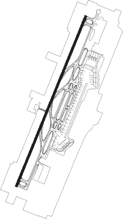
Runway info
| Runway 03 / 21 | ||
| length | 3603m (11821ft) | |
| bearing | 29° / 209° | |
| width | 45m (148ft) | |
| surface | concrete | |
| blast zone | 65m (213ft) / 65m (213ft) | |
Nearby beacons
| code | identifier | dist | bearing | frequency |
|---|---|---|---|---|
| N | FUZHOU NDB | 0.4 | 15° | 229 |
| FOC | FUZHOU VOR/DME | 0.7 | 239° | 116.80 |
| LJG | LIANJIANG VOR/DME | 17.5 | 335° | 117.60 |
| NK | NANGAN (MATSU) NDB | 19.5 | 54° | 315 |
| NKN | DME-ILS | 19.7 | 53° | 110.10 |
| FQG | FUQING VOR/DME | 20 | 234° | 117.40 |
| MT | MATSU NDB | 21.8 | 50° | 210 |
| MTS | DME | 21.8 | 50° | 112.70 |
| PK | MATSU NDB | 24 | 50° | 275 |
| PKN | DME-ILS | 24 | 50° | 109.70 |
Departure and arrival routes
| Transition altitude | 9842ft |
| Transition level | 11811ft |
| SID end points | distance | outbound heading | |
|---|---|---|---|
| RW03 | |||
| DS65K, DS63K, DS61K | 76mi | 24° | |
| DST01D | 120mi | 28° | |
| XL61K, XLN01D, XL63K | 123mi | 230° | |
| BZ63K, BZ61K, BZ01D | 129mi | 357° | |
| RW21 | |||
| DS68K, DS66K, DS62K, DS64K | 76mi | 24° | |
| DST11D | 120mi | 28° | |
| XLN11D, XL64K, XL66K, XL68K, XL62K | 123mi | 230° | |
| BZ66K, BZ64K, BZ11D, BZ62K | 129mi | 357° | |
| STAR starting points | distance | inbound heading | |
|---|---|---|---|
| RW03 | |||
| XLN01A | 122.6 | 50° | |
| XL53J, XL51J | 54.8 | 51° | |
| BZ01A, BZ55J, BZ51J, BZ53J | 129.3 | 177° | |
| DS51J, DS55J, DS53J | 75.8 | 204° | |
| DST01A | 119.6 | 208° | |
| PON51J | 43.8 | 294° | |
| RW21 | |||
| XL54J, XLN11A | 122.6 | 50° | |
| XL56J, XL52J | 54.8 | 51° | |
| BZ56J, BZ54J, BZ52J, BZ11A | 129.3 | 177° | |
| DS56J, DS54J, DS52J | 75.8 | 204° | |
| DST11A | 119.6 | 208° | |
| PON11A | 43.8 | 294° | |
Holding patterns
| STAR name | hold at | type | turn | heading* | altitude | leg | speed limit |
|---|---|---|---|---|---|---|---|
| BZ51J | LJG | NDB | left | 336 (156)° | > 6900ft | 1.0min timed | 245 |
| BZ52J | LJG | NDB | left | 336 (156)° | > 6900ft | 1.0min timed | 245 |
| BZ53J | LJG | NDB | left | 336 (156)° | > 6900ft | 1.0min timed | 245 |
| BZ54J | FZ011 | VHF | right | 4 (184)° | > 9850ft | 1.0min timed | 245 |
| BZ55J | FZ011 | VHF | right | 4 (184)° | > 9850ft | 1.0min timed | 245 |
| BZ56J | FZ011 | VHF | right | 4 (184)° | > 9850ft | 1.0min timed | 245 |
| DS51J | FZ011 | VHF | right | 4 (184)° | > 9850ft | 1.0min timed | 245 |
| DS51J | LJG | NDB | left | 336 (156)° | > 6900ft | 1.0min timed | 245 |
| DS52J | FZ011 | VHF | right | 4 (184)° | > 9850ft | 1.0min timed | 245 |
| DS52J | LJG | NDB | left | 336 (156)° | > 6900ft | 1.0min timed | 245 |
| DS53J | FZ011 | VHF | right | 4 (184)° | > 9850ft | 1.0min timed | 245 |
| DS54J | FZ011 | VHF | right | 4 (184)° | > 9850ft | 1.0min timed | 245 |
| DS55J | FZ011 | VHF | right | 4 (184)° | > 9850ft | 1.0min timed | 245 |
| DS56J | FZ011 | VHF | right | 4 (184)° | > 9850ft | 1.0min timed | 245 |
| PON11A | D041T | VHF | right | 221 (41)° | > 5910ft | 1.0min timed | 245 |
| XL51J | FQG | NDB | right | 278 (98)° | > 6890ft | 1.0min timed | 245 |
| XL52J | FQG | NDB | right | 278 (98)° | > 6890ft | 1.0min timed | 245 |
| XL53J | FZ015 | VHF | left | 231 (51)° | > 6890ft | 1.0min timed | 245 |
| XL54J | FQG | NDB | right | 278 (98)° | > 6890ft | 1.0min timed | 245 |
| XL54J | LJG | NDB | left | 336 (156)° | > 6900ft | 1.0min timed | 245 |
| XL56J | FZ015 | VHF | left | 231 (51)° | > 6890ft | 1.0min timed | 245 |
| XLN01A | FQG | NDB | right | 278 (98)° | > 6890ft | 1.0min timed | 245 |
| XLN11A | D041T | VHF | right | 221 (41)° | > 5910ft | 1.0min timed | 245 |
| XLN11A | FQG | NDB | right | 278 (98)° | > 6890ft | 1.0min timed | 245 |
| *) magnetic outbound (inbound) holding course | |||||||
Disclaimer
The information on this website is not for real aviation. Use this data with the X-Plane flight simulator only! Data taken with kind consent from X-Plane 12 source code and data files. Content is subject to change without notice.