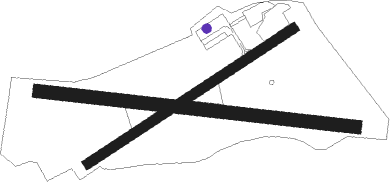
Elizabeth Field - Elizabeth Fld
Airport details
| Country | United States of America |
| State | New York |
| Region | K6 |
| Airspace | Boston Ctr |
| Municipality | Town of Southold |
| Elevation | 7ft (2m) |
| Timezone | GMT -5 |
| Coordinates | 41.25131, -72.03161 |
| Magnetic var | |
| Type | land |
| Available since | X-Plane v10.40 |
| ICAO code | 0B8 |
| IATA code | n/a |
| FAA code | n/a |
Communication
| ELIZABETH FLD CTAF/UNICOM | 122.800 |
| ELIZABETH FLD PROVIDENCE Approach/Departure | 125.750 |
Nearby Points of Interest:
Branford House
-Edward Yeomans House
-Harkness Memorial State Park
-Eugene O'Neill Theater Center
-The Seaside
-Monte Cristo Cottage
-Jabez Smith House
-Ohev Sholem Synagogue
-United States Post Office–New London Main
-Whale Oil Row
-Acors Barns House
-Central Vermont Railroad Pier
-Pequot Fort
-Williams Memorial Institute
-Jonathan Newton Harris House
-Sabino
-Nathan A. Woodworth House
-Winthrop Mill
-James Merrill House
-Stonington High School
-Pequotsepos Manor
-John Palmer House
-Capt. Nathaniel B. Palmer House
-Deshon-Allyn House
-House at 130 Mohegan Avenue
Nearby beacons
| code | identifier | dist | bearing | frequency |
|---|---|---|---|---|
| GON | GROTON VOR/DME | 4.8 | 346° | 110.85 |
| ORW | NORWICH VOR/DME | 18.3 | 6° | 110 |
| SEY | SANDY POINT (BLOCK ISLAND VOR/DME | 21.1 | 100° | 117.80 |
| HTO | HAMPTON (EAST HAMPTON) VORTAC | 23.7 | 221° | 113.60 |
| MAD | MADISON VOR/DME | 30 | 275° | 110.40 |
| HFD | HARTFORD VOR/DME | 32.9 | 307° | 114.90 |
| FOK | SUFFOLK CO (WESTHAMPTON B TACAN | 36.8 | 235° | 111 |
| HVN | HAVEN DME | 38.5 | 271° | 109.80 |
| PVD | PROVIDENCE VOR/DME | 39.2 | 52° | 115.60 |
| CCC | CALVERTON VOR/DME | 39.7 | 247° | 117.20 |
| PUT | PUTNAM VOR/DME | 43.1 | 15° | 117.40 |
| CEF | WESTOVER(SPRINGFIELD/CHIC TACAN | 61 | 332° | 114 |
| BAF | BARNES (WESTFIELD/SPRINGF VORTAC | 62.7 | 323° | 113 |
| OW | STOGE (NORWOOD) NDB | 66 | 46° | 397 |
Disclaimer
The information on this website is not for real aviation. Use this data with the X-Plane flight simulator only! Data taken with kind consent from X-Plane 12 source code and data files. Content is subject to change without notice.

