Hilltop Lakes
Airport details
| Country | United States of America |
| State | Texas |
| Region | |
| Airspace | Houston Oceanic Ctr |
| Municipality | Leon County |
| Elevation | 500ft (152m) |
| Timezone | GMT -6 |
| Coordinates | 31.08483, -96.21597 |
| Magnetic var | |
| Type | land |
| Available since | X-Plane v10.40 |
| ICAO code | 0TE4 |
| IATA code | n/a |
| FAA code | 0TE4 |
Communication
Nearby Points of Interest:
Franklin Carnegie Library
-Hammond House
-Calvert Historic District
-R. Q. Astin House
-Old Sinclair Station
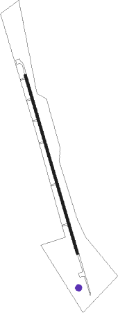
Runway info
| Runway 17 / 35 | ||
| length | 919m (3015ft) | |
| bearing | 166° / 346° | |
| width | 12m (40ft) | |
| surface | asphalt | |
Nearby beacons
| code | identifier | dist | bearing | frequency |
|---|---|---|---|---|
| LOA | LEONA VORTAC | 12.9 | 81° | 110.80 |
| CLL | COLLEGE STATION VORTAC | 30.6 | 203° | 113.30 |
| GNL | GROESBECK (MEXIA) VOR/DME | 34.3 | 326° | 108.80 |
| CL | ROWDY (COLLEGE STATION) NDB | 36 | 192° | 260 |
| LXY | MEXIA NDB | 36.6 | 332° | 329 |
| UTS | HUNTSVILLE NDB | 38.2 | 119° | 308 |
| TNV | NAVASOTA VOR/DME | 48.5 | 169° | 115.90 |
| ROB | ROBINSON (WACO) NDB | 50.5 | 296° | 400 |
| CX | ALIBI (HOUSTON) NDB | 54.7 | 131° | 281 |
| CRS | CORSICANA NDB | 57.4 | 349° | 396 |
| CGQ | POWELL (CORSICANA) NDB | 59.7 | 348° | 344 |
| CSZ | CROSSROADS NDB | 60.2 | 15° | 215 |
| FZT | FRANKSTON VOR/DME | 69 | 35° | 111.40 |
Disclaimer
The information on this website is not for real aviation. Use this data with the X-Plane flight simulator only! Data taken with kind consent from X-Plane 12 source code and data files. Content is subject to change without notice.