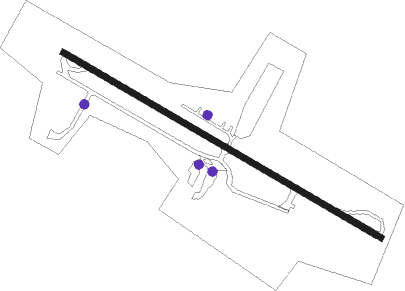
Westminster - Clearview Airpark
Airport details
| Country | United States of America |
| State | Maryland |
| Region | |
| Airspace | New York Ctr |
| Municipality | Carroll County |
| Elevation | 810ft (247m) |
| Timezone | GMT -5 |
| Coordinates | 39.46847, -77.02012 |
| Magnetic var | |
| Type | land |
| Available since | X-Plane v10.40 |
| ICAO code | 2W2 |
| IATA code | n/a |
| FAA code | 2W2 |
Communication
Nearby Points of Interest:
McMurray-Frizzell-Aldridge Farm
-Andrew P. Frizzell House and Farm Complex
-New Windsor Historic District
-Warfield Complex, Hubner, and T Buildings
-Sykesville Historic District
-Moses Brown House
-Appler-Englar House
-Branton Manor
-Roop's Mill
-Stoner-Saum Farm
-Hopewell
-McKinstry's Mills Historic District
-Roberts Inn
-Hard Lodging
-Pipe Creek Friends Meetinghouse
-Reisterstown Historic District
-Slagle-Byers House
-Union Bridge Historic District
-Union Bridge Station
-Glyndon Historic District
-Mount Pleasant
-Robinson-Tabb House
-Trevanion
-Jacob Koons Farm
-Granite Historic District
Runway info
| Runway 14 / 32 | ||
| length | 561m (1841ft) | |
| bearing | 118° / 298° | |
| width | 9m (30ft) | |
| surface | asphalt | |
| displ threshold | 100m (328ft) / 84m (276ft) | |
Nearby beacons
| code | identifier | dist | bearing | frequency |
|---|---|---|---|---|
| EMI | WESTMINSTER VORTAC | 2.4 | 57° | 117.90 |
| FND | ELLICOTT (BALTIMORE) NDB | 15.6 | 127° | 371 |
| FDK | FREDERICK VOR | 16.8 | 261° | 109 |
| BAL | BALTIMORE VORTAC | 24.4 | 130° | 115.10 |
| BUH | ANNE ARUNDEL (FT MEADE) NDB | 26 | 146° | 260 |
| MTN | MARTIN (BALTIMORE) TACAN | 29.4 | 103° | 134.10 |
| GTN | GEORGETOWN (WASH., D.C.) NDB | 32.7 | 191° | 323 |
| DCA | WASHINGTON, D.C. VOR/DME | 36.5 | 182° | 111 |
| AML | ARMEL (WASH.,D.C.) VOR/DME | 38.2 | 220° | 113.50 |
| MRB | MARTINSBURG VORTAC | 38.7 | 264° | 112.10 |
| ADW | ANDREWS (CAMP SPRINGS) VORTAC | 40.3 | 167° | 113.10 |
| HGR | HAGERSTOWN VOR | 41 | 285° | 109.80 |
| DCA | OXONN (WASHINGTON) NDB | 42.1 | 181° | 332 |
| CX | LATLE (HARRISBURG) NDB | 42.6 | 1° | 219 |
| MD | ENOLA (HARRISBURG) NDB | 47 | 9° | 204 |
| OTT | NOTTINGHAM VORTAC | 47.5 | 160° | 113.70 |
| DAA | DAVEE (FT BELVOIR) NDB | 48.6 | 186° | 223 |
| HAR | HARRISBURG VORTAC | 50.1 | 357° | 112.50 |
| THS | SAINT THOMAS VORTAC | 51.2 | 297° | 115 |
| LRP | LANCASTER VOR/DME | 51.5 | 48° | 117.30 |
| BZJ | BELLGROVE (INDIANTOWN GAP) NDB | 61.9 | 26° | 328 |
| CSN | CASANOVA VORTAC | 63.4 | 226° | 116.30 |
Instrument approach procedures
| runway | airway (heading) | route (dist, bearing) |
|---|---|---|
| RW14 | GATHR (141°) | GATHR JHONY (6mi, 197°) 3000ft |
| RNAV | JHONY 3000ft HAMPR (5mi, 118°) 2400ft 2W2 (5mi, 118°) 802ft (4805mi, 117°) 1500ft BENDI (4799mi, 297°) 3000ft BENDI (turn) |
Disclaimer
The information on this website is not for real aviation. Use this data with the X-Plane flight simulator only! Data taken with kind consent from X-Plane 12 source code and data files. Content is subject to change without notice.
