Niles - Jerry Tyler Mem
Airport details
| Country | United States of America |
| State | Michigan |
| Region | K5 |
| Airspace | Chicago Ctr |
| Municipality | Niles |
| Elevation | 750ft (229m) |
| Timezone | GMT -5 |
| Coordinates | 41.83589, -86.22517 |
| Magnetic var | |
| Type | land |
| Available since | X-Plane v10.40 |
| ICAO code | 3TR |
| IATA code | NLE |
| FAA code | 3TR |
Communication
| JERRY TYLER MEM CTAF/UNICOM | 122.800 |
| JERRY TYLER MEM SOUTH BEND Approach/Departure | 118.550 |
Nearby Points of Interest:
Henry A. Chapin House
-Niles Downtown Historic District
-Ring Lardner House
-Old U.S. Post Office
-Fort St. Joseph
-St. Patrick's Farm
-Buchanan Downtown Historic District
-Zinc Collar Pad Company Building
-Buchanan North and West Neighborhoods Historic District
-Wertz-Bestle Farm
-Moccasin Bluff Site
-St. Joseph County Infirmary
-LaFortune Student Center
-Bond Hall
-Berrien Springs Courthouse
-Old Berrien County Courthouse Complex
-Maurice Egan House
-Muessel-Drewry Brewery
-Samuel Leeper Jr. House
-Fire Station No. 7
-Chapin Park Historic District
-Horatio Chapin House
-Singer Manufacturing-South Bend Lathe Co. Historic District
-Normain Heights Historic District
-LaSalle Annex
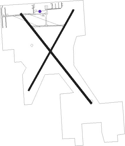
Runway info
Runway 15 / 33  | ||
| length | 1250m (4101ft) | |
| bearing | 138° / 318° | |
| width | 23m (75ft) | |
| surface | asphalt | |
| displ threshold | 91m (299ft) / 0m (0ft) | |
| Runway 4 / 22 | ||
| length | 1011m (3317ft) | |
| bearing | 42° / 222° | |
| width | 17m (55ft) | |
| surface | asphalt | |
| displ threshold | 274m (899ft) / 229m (751ft) | |
Nearby beacons
| code | identifier | dist | bearing | frequency |
|---|---|---|---|---|
| GIJ | GIPPER (NILES) VORTAC | 5.8 | 234° | 115.40 |
| SB | MISHA (SOUTH BEND) NDB | 7.8 | 177° | 341 |
| ELX | KEELER VOR/DME | 19 | 18° | 116.60 |
| GSH | GOSHEN VORTAC | 20.6 | 148° | 113.70 |
| IRS | STURGIS NDB | 35.4 | 92° | 382 |
| AZ | AUSTN (KALAMAZOO) NDB | 35.7 | 67° | 371 |
| OXI | KNOX VOR/DME | 36.2 | 220° | 115.60 |
| VP | SEDLY (VALPARAISO) NDB | 37.2 | 239° | 212 |
| PMM | PULLMAN VOR/DME | 38.2 | 11° | 112.10 |
| AZO | KALAMAZOO VOR/DME | 38.4 | 59° | 109 |
| OLK | WEBSTER LAKE VOR | 48.1 | 129° | 110.40 |
| VIO | VICTORY VOR/DME | 65.6 | 37° | 115.95 |
Instrument approach procedures
| runway | airway (heading) | route (dist, bearing) |
|---|---|---|
| RW15 | GIJ (54°) | GIJ IBEBY (14mi, 346°) 2500ft IBEBY (turn) 2500ft |
| RW15 | LINGS (267°) | LINGS IBEBY (24mi, 287°) 2500ft IBEBY (turn) 2500ft |
| RW15 | MAPER (111°) | MAPER IBEBY (16mi, 94°) 2500ft |
| RW15 | ZIVDO (179°) | ZIVDO IBEBY (10mi, 230°) 2500ft |
| RNAV | IBEBY 2500ft CIVPU (6mi, 138°) 2500ft 3TR (6mi, 138°) 781ft (5236mi, 116°) 1150ft JJANN (5226mi, 296°) 3000ft JJANN (turn) | |
| RW33 | AYUYI (284°) | AYUYI FEVAX (14mi, 260°) 3500ft |
| RW33 | GIJ (54°) | GIJ FEVAX (12mi, 112°) 3500ft FEVAX (turn) 3500ft |
| RW33 | JJANN (240°) | JJANN FEVAX (19mi, 197°) 3500ft FEVAX (turn) 3500ft |
| RNAV | FEVAX 3500ft HEGUD (6mi, 318°) 2500ft 3TR (6mi, 318°) 790ft (5236mi, 116°) 1150ft JJANN (5226mi, 296°) 3000ft JJANN (turn) |
Disclaimer
The information on this website is not for real aviation. Use this data with the X-Plane flight simulator only! Data taken with kind consent from X-Plane 12 source code and data files. Content is subject to change without notice.