Rector
Airport details
| Country | United States of America |
| State | Arkansas |
| Region | K4 |
| Airspace | Memphis Ctr |
| Municipality | Clay County |
| Elevation | 280ft (85m) |
| Timezone | GMT -6 |
| Coordinates | 36.25006, -90.31954 |
| Magnetic var | |
| Type | land |
| Available since | X-Plane v10.40 |
| ICAO code | 7M8 |
| IATA code | n/a |
| FAA code | 7M8 |
Communication
| Rector CTAF | 122.900 |
Nearby Points of Interest:
Scatterville Cemetery
-Knob School
-Pfeiffer House and Carriage House
-Piggott National Guard Armory
-Ely and Walker Shirt Factory No. 5
-George Ray's Dragstrip
-National Bank of Commerce Building (Paragould, Arkansas)
-Greene County Courthouse
-Beisel-Mitchell House
-Highfill-McClure House
-Jackson-Herget House
-Linwood Mausoleum
-Oliver House
-Sheeks House
-Craighead County Road 513C Bridge
-Crowley's Ridge State Park-Dining Hall
-Crowley's Ridge State Park-Comfort Station
-Crowley's Ridge State Park-Bridge
-Crowley's Ridge State Park-Bathhouse
-First National Bank Building
-Jonesboro, Lake City & Eastern Railroad Depot
-Herman Davis State Park
-West Main Street Residential Historic District
-Blytheville Greyhound Bus Station
-Mississippi County Courthouse
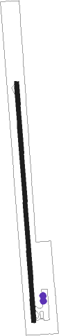
Runway info
| Runway 18 / 36 | ||
| length | 1039m (3409ft) | |
| bearing | 180° / 0° | |
| width | 18m (60ft) | |
| surface | asphalt | |
| displ threshold | 0m (0ft) / 81m (266ft) | |
Nearby beacons
| code | identifier | dist | bearing | frequency |
|---|---|---|---|---|
| JBR | JONESBORO VOR/DME | 26 | 216° | 108.60 |
| MAW | MALDEN VORTAC | 26.9 | 53° | 111.20 |
| TNZ | LAWRENCE COUNTY (WALNUT RIDGE) NDB | 29.3 | 266° | 227 |
| ARG | WALNUT RIDGE VORTAC | 31.8 | 258° | 114.50 |
| GQE | GILMORE VOR/DME | 54.7 | 190° | 113 |
| CGI | GIRARDEAU DME | 68.8 | 37° | 112.90 |
Disclaimer
The information on this website is not for real aviation. Use this data with the X-Plane flight simulator only! Data taken with kind consent from X-Plane 12 source code and data files. Content is subject to change without notice.