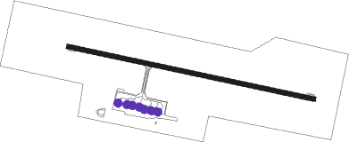
Tokua
Airport details
| Country | Papua New Guinea |
| State | East New Britain |
| Region | AY |
| Airspace | Port Moresby Ctr |
| Municipality | Kokopo District |
| Elevation | 26ft (8m) |
| Timezone | GMT +10 |
| Coordinates | -4.34103, 152.37921 |
| Magnetic var | |
| Type | land |
| Available since | X-Plane v10.40 |
| ICAO code | AYTK |
| IATA code | RAB |
| FAA code | n/a |
Communication
| Tokua ATIS | 128.300 |
| Tokua Tower | 118.200 |
Runway info
| Runway 10 / 28 | ||
| length | 1722m (5650ft) | |
| bearing | 107° / 287° | |
| width | 30m (98ft) | |
| surface | asphalt | |
| blast zone | 58m (190ft) / 60m (197ft) | |
Instrument approach procedures
| runway | airway (heading) | route (dist, bearing) |
|---|---|---|
| RW10 | VASNO (43°) | VASNO YTKWA (15mi, 16°) 4300ft YTKWI (6mi, 16°) 2800ft |
| RW10 | YTKWB (107°) | YTKWB 4300ft YTKWI (6mi, 107°) 2800ft |
| RNAV | YTKWI 2800ft YTKWF (5mi, 107°) 1700ft YTKWM (5mi, 106°) 74ft YTKWT (3mi, 106°) YTKWH (8mi, 5°) (9137mi, 272°) 4300ft | |
| RW28 | IGBAR (196°) | IGBAR YTKSD (12mi, 135°) 3600ft YTKSI (6mi, 196°) 3000ft |
| RW28 | VASNO (43°) | VASNO YTKSG (25mi, 71°) 3600ft YTKSI (6mi, 16°) 3000ft |
| RNAV | YTKSI 3000ft YTKSF (5mi, 286°) 1700ft YTKSM (5mi, 286°) 116ft YTKSH (5mi, 286°) (9129mi, 272°) 4300ft |
Disclaimer
The information on this website is not for real aviation. Use this data with the X-Plane flight simulator only! Data taken with kind consent from X-Plane 12 source code and data files. Content is subject to change without notice.
