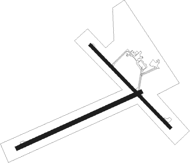
Lethbridge
Airport details
| Country | Canada |
| State | Alberta |
| Region | CY |
| Airspace | Edmonton Ctr |
| Municipality | Lethbridge County |
| Elevation | 3047ft (929m) |
| Timezone | GMT -7 |
| Coordinates | 49.63028, -112.79694 |
| Magnetic var | |
| Type | land |
| Available since | X-Plane v10.40 |
| ICAO code | CYQL |
| IATA code | YQL |
| FAA code | n/a |
Communication
| Lethbridge AWOS | 124.400 |
| Lethbridge MF | 121.000 |
| Lethbridge Edm Ctr | 132.750 |
Approach frequencies
| ILS-cat-I | RW06 | 109.5 | 18.00mi |
| 3° GS | RW06 | 109.5 | 18.00mi |
Nearby beacons
| code | identifier | dist | bearing | frequency |
|---|---|---|---|---|
| QL | LETHBRIDGE NDB | 4 | 256° | 248 |
| YQL | LETHBRIDGE VOR/DME | 5 | 88° | 115.70 |
| Z7 | CLARESHOLM INDUSTRIAL NDB | 39.4 | 294° | 408 |
Instrument approach procedures
| runway | airway (heading) | route (dist, bearing) |
|---|---|---|
| RW06 | DUPIV (91°) | DUPIV AVSOK (6mi, 128°) 4700ft |
| RW06 | MIPUP (59°) | MIPUP AVSOK (6mi, 360°) 4700ft |
| RNAV | AVSOK 4700ft BEXUT (6mi, 77°) 4400ft CYQL (5mi, 76°) 3090ft SEPTO (4mi, 78°) 5100ft SEPTO (turn) | |
| RW13 | SUTSA (107°) | SUTSA MOGET (5mi, 61°) 4700ft |
| RW13 | UDMUB (159°) | UDMUB MOGET (5mi, 242°) 4700ft |
| RNAV | MOGET 4700ft TUKAT (6mi, 128°) 4400ft CYQL (5mi, 130°) 3055ft VIRBI (7mi, 127°) 4800ft VIRBI (turn) | |
| RW24 | OLITU (273°) | OLITU NORIG (6mi, 308°) 4400ft |
| RW24 | OMSUS (239°) | OMSUS NORIG (6mi, 181°) 4400ft |
| RNAV | NORIG 4400ft VOLOT (6mi, 257°) 4400ft CYQL (4mi, 258°) 3065ft XOVEM (5mi, 256°) 4800ft XOVEM (turn) | |
| RW31 | MIPUR (337°) | MIPUR UMABU (5mi, 62°) 4500ft |
| RW31 | OMTEM (287°) | OMTEM UMABU (5mi, 242°) 4500ft |
| RNAV | UMABU 4500ft SIDPI (6mi, 308°) 4400ft CYQL (5mi, 306°) 3068ft VIXUP (6mi, 309°) 4800ft VIXUP (turn) |
Disclaimer
The information on this website is not for real aviation. Use this data with the X-Plane flight simulator only! Data taken with kind consent from X-Plane 12 source code and data files. Content is subject to change without notice.

