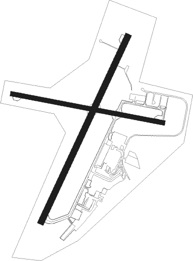
Sudbury
Airport details
| Country | Canada |
| State | Ontario |
| Region | CY |
| Airspace | Toronto Ctr |
| Municipality | Greater Sudbury |
| Elevation | 1141ft (348m) |
| Timezone | GMT -5 |
| Coordinates | 46.61597, -80.80238 |
| Magnetic var | |
| Type | land |
| Available since | X-Plane v10.40 |
| ICAO code | CYSB |
| IATA code | YSB |
| FAA code | n/a |
Communication
| Sudbury ATIS | 127.400 |
| Sudbury RADIO | 125.500 |
| Sudbury Clearance DEL | 121.800 |
| Sudbury CTR Toronto | 135.500 |
Approach frequencies
| ILS-cat-I | RW22 | 110.3 | 18.00mi |
| 3° GS | RW22 | 110.3 | 18.00mi |
Nearby beacons
| code | identifier | dist | bearing | frequency |
|---|---|---|---|---|
| YSB | DME | 0.8 | 17° | 112.30 |
| SB | SUDBURY NDB | 5.3 | 285° | 362 |
Departure and arrival routes
| Transition altitude | 18000ft |
| Transition level | 18000ft |
| SID end points | distance | outbound heading | |
|---|---|---|---|
| RW04 | |||
| CYSB2 | 58mi | 101° | |
| RW12 | |||
| CYSB2 | 58mi | 101° | |
| RW22 | |||
| CYSB2 | 58mi | 101° | |
| RW30 | |||
| CYSB2 | 58mi | 101° | |
Instrument approach procedures
| runway | airway (heading) | route (dist, bearing) |
|---|---|---|
| RW04 | KESNA (5°) | KESNA PEKVU (5mi, 291°) 3600ft |
| RW04 | XORIV (65°) | XORIV PEKVU (5mi, 111°) 3600ft |
| RNAV | PEKVU 3600ft OBTIR (6mi, 39°) 2500ft UBTEX (3mi, 39°) 1630ft CYSB (1mi, 46°) 1180ft EMLOS (5mi, 38°) 3500ft EMLOS (turn) | |
| RW12 | BEMUB (86°) | BEMUB ALTAP (5mi, 22°) 3600ft |
| RW12 | DUSAL (123°) | DUSAL ALTAP (5mi, 201°) 3600ft |
| RNAV | ALTAP 3600ft URPEM (6mi, 101°) 2600ft CYSB (5mi, 107°) 1178ft ITNIP (5mi, 95°) 3500ft ITNIP (turn) | |
| RW22 | ESPUS (242°) | ESPUS UKSUT (5mi, 291°) 3500ft |
| RW22 | OXAKI (188°) | OXAKI UKSUT (5mi, 111°) 3500ft |
| RNAV | UKSUT 3500ft ALNIL (6mi, 220°) 2600ft CYSB (6mi, 218°) 1189ft BOTIV (turn) IMAGI (3mi, 219°) 3500ft IMAGI (turn) | |
| RW30 | OMSOK (261°) | OMSOK MEGDU (5mi, 202°) 3600ft |
| RW30 | VOGUR (298°) | VOGUR MEGDU (5mi, 22°) 3600ft |
| RNAV | MEGDU 3600ft KATEV (6mi, 281°) 2600ft CYSB (5mi, 275°) 1193ft URLIS (5mi, 287°) 3500ft URLIS (turn) |
Disclaimer
The information on this website is not for real aviation. Use this data with the X-Plane flight simulator only! Data taken with kind consent from X-Plane 12 source code and data files. Content is subject to change without notice.

