Taloyoak
Airport details
| Country | Canada |
| State | Nunavut |
| Region | CY |
| Airspace | Edmonton Ctr |
| Municipality | Taloyoak |
| Elevation | 90ft (27m) |
| Timezone | GMT -7 |
| Coordinates | 69.54665, -93.57702 |
| Magnetic var | |
| Type | land |
| Available since | X-Plane v10.40 |
| ICAO code | CYYH |
| IATA code | YYH |
| FAA code | n/a |
Communication
| Taloyoak MANDATORY FREQ | 122.100 |
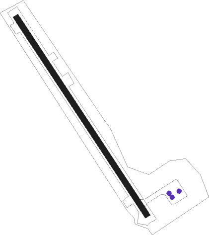
Runway info
| Runway 15 / 33 | ||
| length | 1241m (4072ft) | |
| bearing | 122° / 302° | |
| width | 30m (100ft) | |
| surface | gravel | |
Nearby beacons
| code | identifier | dist | bearing | frequency |
|---|---|---|---|---|
| YYH | TALOYOAK NDB | 1.1 | 96° | 290 |
Instrument approach procedures
| runway | airway (heading) | route (dist, bearing) |
|---|---|---|
| RW15 | LERIB (166°) | LERIB GONOM (5mi, 259°) 1700ft |
| RW15 | PUPOR (105°) | PUPOR GONOM (5mi, 79°) 1700ft |
| RNAV | GONOM 1700ft BOTUK (6mi, 122°) 1700ft CYYH (5mi, 122°) 140ft EMEPA (2mi, 122°) AVPUM (3mi, 122°) 2100ft AVPUM (turn) | |
| RW33 | IPTIK (285°) | IPTIK ONBUR (5mi, 259°) 1700ft |
| RW33 | UKSEN (345°) | UKSEN ONBUR (5mi, 79°) 1700ft |
| RNAV | ONBUR 1700ft KELRU (6mi, 302°) 1700ft CYYH (5mi, 302°) 105ft ALVEL (2mi, 302°) DUMLI (3mi, 302°) 2000ft DUMLI (turn) |
Disclaimer
The information on this website is not for real aviation. Use this data with the X-Plane flight simulator only! Data taken with kind consent from X-Plane 12 source code and data files. Content is subject to change without notice.