Annabah - Rabah Bitat
Airport details
| Country | Algeria |
| State | Annaba |
| Region | DA |
| Airspace | Algiers Ctr |
| Municipality | El Bouni |
| Elevation | 16ft (5m) |
| Timezone | GMT +1 |
| Coordinates | 36.82812, 7.80319 |
| Magnetic var | |
| Type | land |
| Available since | X-Plane v10.40 |
| ICAO code | DABB |
| IATA code | AAE |
| FAA code | n/a |
Communication
| Rabah Bitat ANNABA TOUR | 118.700 |
| Rabah Bitat ANNABA Approach | 119.700 |
Approach frequencies
| ILS-cat-I | RW18 | 109.7 | 18.00mi |
| 3° GS | RW18 | 109.7 | 18.00mi |
Nearby Points of Interest:
El Feidja National Park
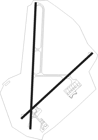
Runway info
Runway 18 / 36  | ||
| length | 3007m (9865ft) | |
| bearing | 189° / 9° | |
| width | 45m (148ft) | |
| surface | asphalt | |
| displ threshold | 0m (0ft) / 101m (331ft) | |
| Runway 05 / 23 | ||
| length | 2289m (7510ft) | |
| bearing | 58° / 238° | |
| width | 45m (149ft) | |
| surface | asphalt | |
| blast zone | 33m (108ft) / 0m (0ft) | |
Nearby beacons
| code | identifier | dist | bearing | frequency |
|---|---|---|---|---|
| ANB | ANNABA VOR/DME | 0.6 | 69° | 113.50 |
| BO | ANNABA NDB | 0.6 | 184° | 392 |
Disclaimer
The information on this website is not for real aviation. Use this data with the X-Plane flight simulator only! Data taken with kind consent from X-Plane 12 source code and data files. Content is subject to change without notice.