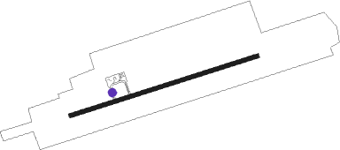
Sokoto - Sultan Abubakar Iii Intl
Airport details
| Country | Nigeria |
| State | Sokoto State |
| Region | DN |
| Airspace | Kano Ctr |
| Municipality | Takatuku Madorawa |
| Elevation | 1008ft (307m) |
| Timezone | GMT +1 |
| Coordinates | 12.91590, 5.20690 |
| Magnetic var | |
| Type | land |
| Available since | X-Plane v10.40 |
| ICAO code | DNSO |
| IATA code | SKO |
| FAA code | n/a |
Communication
| Sultan Abubakar III Intl SOKOTO Tower | 122.100 |
| Sultan Abubakar III Intl SOKOTO Tower | 124.500 |
Approach frequencies
| ILS-cat-I | RW08 | 109.5 | 18.00mi |
| 3.1° GS | RW08 | 109.5 | 18.00mi |
Nearby beacons
| code | identifier | dist | bearing | frequency |
|---|---|---|---|---|
| SK | SOKOTO NDB | 1.3 | 257° | 397 |
| SOK | SOKOTO VOR/DME | 1.3 | 77° | 113.90 |
| BIK | BIRNIN KEBBI VOR/DME | 54.2 | 243° | 112.20 |
Instrument approach procedures
| runway | airway (heading) | route (dist, bearing) |
|---|---|---|
| RW08 | AMBUM (99°) | AMBUM GUMER (5mi, 166°) 3000ft |
| RW08 | DEVDU (77°) | DEVDU GUMER (5mi, 77°) 3000ft |
| RW08 | VOPKU (54°) | VOPKU GUMER (5mi, 346°) 3000ft |
| RNAV | GUMER 3000ft SO800 (5mi, 77°) 3000ft DNSO (7mi, 77°) 1051ft VOPKU (13mi, 234°) GUMER (5mi, 346°) GUMER (turn) 3000ft | |
| RW26 | NUKOG (279°) | NUKOG BOVTI (5mi, 346°) 3000ft |
| RW26 | ODMEM (257°) | ODMEM BOVTI (5mi, 257°) 3000ft |
| RW26 | OGBEB (234°) | OGBEB BOVTI (5mi, 166°) 3000ft |
| RNAV | BOVTI 3000ft SO620 (5mi, 257°) 3000ft DNSO (7mi, 257°) 1060ft NUKOG (13mi, 99°) BOVTI (5mi, 346°) BOVTI (turn) 3000ft |
Disclaimer
The information on this website is not for real aviation. Use this data with the X-Plane flight simulator only! Data taken with kind consent from X-Plane 12 source code and data files. Content is subject to change without notice.
