Thorntonville - Roy Hurd Mem
Airport details
| Country | United States of America |
| State | Texas |
| Region | K4 |
| Airspace | Ft Worth Ctr |
| Municipality | Monahans |
| Elevation | 2615ft (797m) |
| Timezone | GMT -6 |
| Coordinates | 31.58247, -102.90903 |
| Magnetic var | |
| Type | land |
| Available since | X-Plane v10.40 |
| ICAO code | E01 |
| IATA code | n/a |
| FAA code | E01 |
Communication
| Roy Hurd Mem CTAF/UNICOM | 122.800 |
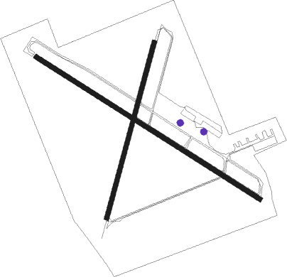
Runway info
Runway 12 / 30  | ||
| length | 1299m (4262ft) | |
| bearing | 123° / 303° | |
| width | 23m (75ft) | |
| surface | asphalt | |
| blast zone | 20m (66ft) / 0m (0ft) | |
| Runway 1 / 19 | ||
| length | 890m (2920ft) | |
| bearing | 23° / 203° | |
| width | 23m (75ft) | |
| surface | asphalt | |
| blast zone | 115m (377ft) / 93m (305ft) | |
Nearby beacons
| code | identifier | dist | bearing | frequency |
|---|---|---|---|---|
| INK | WINK VORTAC | 24.5 | 311° | 112.10 |
| PEQ | PECOS (PECOS CITY) VOR/DME | 34.7 | 260° | 111.80 |
| FST | FORT STOCKTON VORTAC | 38 | 186° | 116.90 |
| MA | FARLY (MIDLAND) NDB | 38.4 | 55° | 326 |
| MAF | MIDLAND VORTAC | 44.7 | 59° | 114.80 |
Instrument approach procedures
| runway | airway (heading) | route (dist, bearing) |
|---|---|---|
| RW12 | INK (131°) | INK POMVE (14mi, 138°) 5000ft |
| RNAV | POMVE 5000ft EGOJO (6mi, 123°) 4000ft E01 (5mi, 123°) 2651ft (6064mi, 107°) 3200ft INK (6079mi, 287°) 6000ft INK (turn) | |
| RW30 | OHARA (260°) | OHARA ZOBUL (19mi, 235°) 5000ft |
| RW30 | ZOBUL (303°) | ZOBUL 5000ft |
| RNAV | ZOBUL 5000ft GENLY (7mi, 303°) 4000ft E01 (5mi, 303°) 2655ft (6064mi, 107°) 3015ft WUVNI (6066mi, 287°) INK (22mi, 312°) 6000ft INK (turn) |
Disclaimer
The information on this website is not for real aviation. Use this data with the X-Plane flight simulator only! Data taken with kind consent from X-Plane 12 source code and data files. Content is subject to change without notice.