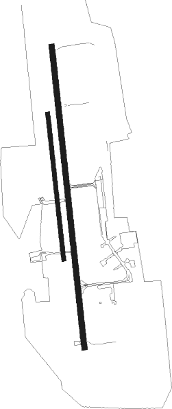
Airports for X-Plane offers a convenient way to explore airports and their related communication information for the X-Plane flight simulator. It only uses data from the X-Plane flight simulator itself, and is therefore more reliable than the data that comes from real aviation websites. You can search for airports by using the ICAO code, or browse for airports per country and state. The information displayed is categorized by airport details, runway information, airport communication, approach frequencies (ILS and Glidepath details), details of nearby beacons, SIDs, STARs and approach procedures.

warfare field grass stolport airport authority aviation air safety ferry international airport airplane southwest air traffic control transit nation aircraft airport propeller plane taxiway bus gravel

Rothenburg/oberlausitz - Rothenburg/görlitz

Airport details

CountryGermany
StateSaxony
RegionED
AirspaceMunich Ctr
MunicipalityRothenburg/Oberlausitz
Elevation518ft (158m)
TimezoneGMT +1
Coordinates51.36317, 14.95000
Magnetic var
Typeland
Available sinceX-Plane v10.40
ICAO codeEDBR
IATA coden/a
FAA coden/a

Communication

Rothenburg/Görlitz Rothenburg Info123.255
Nearby Points of Interest:
Kirche Hähnichen
-
Bahnhof Horka Gbf
-
Schloss Daubitz
-
Evangelische Kirche Niesky
-
Kirche Kosel
-
Przewóz Castle
-
Trinitatiskirche
-
Schloss Niederrengersdorf
-
Kirche Niederrengersdorf
-
Kościół ewangelicki w Ruszowie
-
Neues Schloss Ober Rengersdorf
-
Königshainer Schlösser
-
Königshainer Schlösser (Sachgesamtheit) Dorfstraße 27; 28; 28a; 29; 30; 30b; 31; 31a; 32
-
Manor in Jędrzychowice
-
Kirche Förstgen
-
Palace in Żarska Wieś
-
Rittergut Arnsdorf
-
Städtischer Friedhof Görlitz
-
Nikolaiturm
-
Jägerkaserne
-
Wheelwright Croft in Zgorzelec
-
Palace in Iłowa
-
Schloss Döbschütz
-
Brautwiesenplatz
-
Stadthalle Görlitz

Runway info

Runway 17 / 35  
 length2498m (8196ft)
 bearing177° / 357°
 width45m (148ft)
 surfaceasphalt
Runway 17R / 35L  
 length1207m (3960ft)
 bearing177° / 357°
 width35m (115ft)
 surfacegrass

Airport layout


Parking locations

Nearby beacons

codeidentifierdistbearingfrequency
OKXFRYDLANT VOR/DME27.8170°114.85
HDOHERMSDORF VOR/DME34233°108.65
ZLGZIELONA GORA VOR/DME56.448°110.65
NERNERATOVICE VOR/DME61.1198°112.25

Disclaimer

The information on this website is not for real aviation. Use this data with the X-Plane flight simulator only! Data taken with kind consent from X-Plane 12 source code and data files. Content is subject to change without notice.