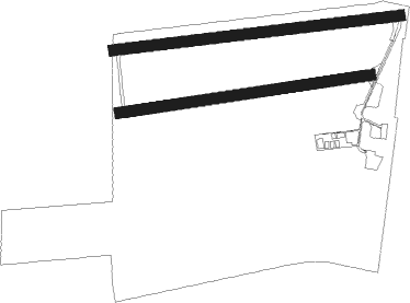
Airports for X-Plane offers a convenient way to explore airports and their related communication information for the X-Plane flight simulator. It only uses data from the X-Plane flight simulator itself, and is therefore more reliable than the data that comes from real aviation websites. You can search for airports by using the ICAO code, or browse for airports per country and state. The information displayed is categorized by airport details, runway information, airport communication, approach frequencies (ILS and Glidepath details), details of nearby beacons, SIDs, STARs and approach procedures.

airbase terminal embassy immigration near arrival flights runway lighting nearby airport authority plane corporation international nation runway airspace arriving gravel airstrip city

Ballenstedt - Ballenstedt-harz

Airport details

CountryGermany
StateSaxony-Anhalt
RegionED
AirspaceMunich Ctr
MunicipalityBallenstedt
Elevation500ft (152m)
TimezoneGMT +1
Coordinates51.74633, 11.23100
Magnetic var
Typeland
Available sinceX-Plane v10.32
ICAO codeEDCB
IATA coden/a
FAA coden/a

Communication

Ballenstedt-Harz Ballenstedt Info122.700
Nearby Points of Interest:
Gersdorfer Burg
-
Marktturm Ballenstedt
-
Rathaus Ballenstedt
-
Schlossteich
-
Neuer Teich
-
Schulungszentrum Großer Ziegenberg
-
Grenzstein
-
Wilhelm-Pieck-Straße 16
-
Holländermühle Gernrode
-
Osterhöhe 53
-
Große Wellbachsmühle
-
Otto-Franke-Straße 16
-
Städtisches Gas- und Elektrizitätswerk Gernrode
-
Kriegerdenkmal Meisdorf
-
Töpferstieg 17
-
Badeborner Weg 16 (Quedlinburg)
-
Walther-Rathenau-Straße 2
-
Villa Irma
-
Junge Familie
-
Otto-Franke-Straße 34
-
Otto-Franke-Straße 38
-
Otto-Franke-Straße 40
-
Postamt Gernrode
-
Wappenstein
-
Mittelstraße 15

Runway info

Runway 09 / 27  
 length802m (2631ft)
 bearing88° / 268°
 width30m (98ft)
 surfaceasphalt
 displ threshold60m (197ft) / 185m (607ft)
Runway 09R / 27L  
 length706m (2316ft)
 bearing87° / 267°
 width30m (98ft)
 surfacegrass
 displ threshold60m (197ft) / 85m (279ft)

Airport layout


Parking locations

Nearby beacons

codeidentifierdistbearingfrequency
CBCOCHSTEDT NDB10.663°344
MAGMAGDEBURG VOR/DME25.666°110.45
GOTGOTEM VOR/DME27.8138°115.25
HLZHEHLINGEN VOR/DME40.4325°117.30
BRUBRAUNSCHWEIG-WOLFSBURG NDB41.5313°427
LNDNORTH(LEIPZIG- DME41.5107°113.50
LLDSOUTH(LEIPZIG- DME42.2108°112.15
EFDDME46.9200°112.05
ERFERFURT VOR/DME47.7180°113.85

Disclaimer

The information on this website is not for real aviation. Use this data with the X-Plane flight simulator only! Data taken with kind consent from X-Plane 12 source code and data files. Content is subject to change without notice.