Leipzig - Leipzig-halle
Airport details
| Country | Germany |
| State | Saxony |
| Region | ED |
| Airspace | Munich Ctr |
| Municipality | Schkeuditz |
| Elevation | 459ft (140m) |
| Timezone | GMT +1 |
| Coordinates | 51.42399, 12.23638 |
| Magnetic var | |
| Type | land |
| Available since | X-Plane v10.40 |
| ICAO code | EDDP |
| IATA code | LEJ |
| FAA code | n/a |
Communication
| Leipzig-Halle EDDP ATIS | 123.950 |
| Leipzig-Halle LEIPZIG DLV | 121.800 |
| Leipzig-Halle LEIPZIG Ground Control | 121.675 |
| Leipzig-Halle LEIPZIG Tower (N) | 125.950 |
| Leipzig-Halle LEIPZIG Tower (S) | 121.100 |
| Leipzig-Halle LEIPZIG Approach | 126.175 |
| Leipzig-Halle LEIPZIG Departure | 126.175 |
Approach frequencies
| ILS-cat-III | RW08L | 108.55 | 18.00mi |
| ILS-cat-III | RW26R | 108.35 | 18.00mi |
| ILS-cat-III | RW26L | 110.3 | 18.00mi |
| ILS-cat-III | RW08R | 111.75 | 18.00mi |
| 3° GS | RW08L | 108.55 | 18.00mi |
| 3° GS | RW26R | 108.35 | 18.00mi |
| 3° GS | RW26L | 110.3 | 18.00mi |
| 3° GS | RW08R | 111.75 | 18.00mi |
Nearby Points of Interest:
Wohnhaus (mit Apotheke) in geschlossener Bebauung, sowie Toreinfahrt an der Mühlstraße Markt 14
-Dorfkirche Radefeld
-Distanzstein
-St. Moritz (Großkugel)
-Dorfkirche Ermlitz
-St. Jacobus (Oberthau)
-Protestant Church (Horburg)
-Gutshaus Gröbers
-Lindenstraße 10
-Hallesche Straße 16
-Gröbers substation
-Mittelstraße 6
-Proitzer Platz 8 (Benndorf)
-Kath. Pfarrkirche Georg-Herwegh-Straße 22
-Diakonissenkrankenhaus Leipzig
-Karl-Heine-Kanal
-Zentralstadion
-Theaterhaus am Lindenauer Markt
-Dorfkirche Naundorf
-Westbad
-Leipzig Aquatic Stadium
-Villa Selter
-Liebfrauenkirche
-Funkhaus Springerstraße
-Villa Hupfeld
Runway info
Runway 08L / 26R  | ||
| length | 3590m (11778ft) | |
| bearing | 87° / 267° | |
| width | 45m (148ft) | |
| surface | concrete | |
| Runway 08R / 26L | ||
| length | 3590m (11778ft) | |
| bearing | 87° / 267° | |
| width | 60m (197ft) | |
| surface | concrete | |
Airport layout
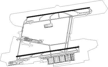
Taxiway locations
Parking locations
|
Nearby beacons
| code | identifier | dist | bearing | frequency |
|---|---|---|---|---|
| LLD | SOUTH(LEIPZIG- DME | 0.5 | 215° | 112.15 |
| LND | NORTH(LEIPZIG- DME | 0.7 | 314° | 113.50 |
| SKZ | SCHKEUDITZ (LEIPZIG-HALLE) NDB | 1.4 | 105° | 357 |
| ZIG | LEIPZIG NDB | 1.7 | 77° | 340 |
| LEG | LEIPZIG VOR/DME | 8.9 | 87° | 115.85 |
| GOT | GOTEM VOR/DME | 24.4 | 263° | 115.25 |
| ABU | ALTENBURG NDB | 27.9 | 147° | 330 |
| AGD | DME | 28.4 | 148° | 115.30 |
| MAG | MAGDEBURG VOR/DME | 38 | 322° | 110.45 |
| HOZ | HOLZDORF NDB | 38.2 | 68° | 406 |
| CB | COCHSTEDT NDB | 39.3 | 299° | 344 |
| HOZ | HOLZDORF TACAN | 41.3 | 70° | 117.25 |
| ERF | ERFURT VOR/DME | 47.1 | 245° | 113.85 |
Departure and arrival routes
| Transition altitude | 5000ft |
| SID end points | distance | outbound heading | |
|---|---|---|---|
| RW08L | |||
| RUDA1Q | 33mi | 62° | |
| GOLA1Q, GOLA1M | 33mi | 210° | |
| NEVK1H, NEVK1Q | 49mi | 239° | |
| ORTA4Q | 43mi | 273° | |
| ODLU4Q | 30mi | 317° | |
| MAG4Q | 38mi | 322° | |
| UMBA4Q | 23mi | 351° | |
| RW08R | |||
| RUDA1E | 33mi | 62° | |
| GOLA1E, GOLA1L | 33mi | 210° | |
| NEVK1E, NEVK1L | 49mi | 239° | |
| ORTA4E | 43mi | 273° | |
| ODLU4E | 30mi | 317° | |
| MAG3E | 38mi | 322° | |
| UMBA4E | 23mi | 351° | |
| RW26L | |||
| RUDA1W | 33mi | 62° | |
| GOLA1S | 33mi | 210° | |
| NEVK1S | 49mi | 239° | |
| ORTA4S | 43mi | 273° | |
| ODLU5S | 30mi | 317° | |
| MAG5S | 38mi | 322° | |
| UMBA4S | 23mi | 351° | |
| RW26R | |||
| RUDA1N | 33mi | 62° | |
| GOLA1N | 33mi | 210° | |
| NEVK1N | 49mi | 239° | |
| ORTA4N | 43mi | 273° | |
| ODLU5N | 30mi | 317° | |
| MAG5N | 38mi | 322° | |
| UMBA4N | 23mi | 351° | |
| STAR starting points | distance | inbound heading | |
|---|---|---|---|
| RW08 (ALL) | |||
| GOXL1R | 31.6 | 65° | |
| GOT1E, GOT1G | 24.4 | 83° | |
| KOJE1R | 27.8 | 97° | |
| LUXB1R | 24.5 | 260° | |
| YAWO1R | 26.7 | 293° | |
| RW08L | |||
| MAXE2N | 13.0 | 1° | |
| RW08R | |||
| MAXE2M | 13.0 | 1° | |
| RW26 (ALL) | |||
| GOXL1V | 31.6 | 65° | |
| GOT1L, GOT1W | 24.4 | 83° | |
| KOJE1V | 27.8 | 97° | |
| LUXB1V | 24.5 | 260° | |
| YAWO1V | 26.7 | 293° | |
| RW26L | |||
| LIPV2M | 14.5 | 331° | |
| RW26R | |||
| LIPV2N | 14.5 | 331° | |
Instrument approach procedures
| runway | airway (heading) | route (dist, bearing) |
|---|---|---|
| RW08L | MOWOX (88°) | MOWOX 5000ft DP431 (4mi, 87°) 4000ft DP432 (4mi, 87°) 3000ft |
| RNAV | DP432 3000ft MOKUL (4mi, 87°) 3000ft EDDP (9mi, 89°) 468ft ZIG (2mi, 77°) (3151mi, 193°) 900ft DP481 (3155mi, 13°) DP981 (27mi, 286°) DP982 (9mi, 230°) DP983 (6mi, 156°) MOWOX (6mi, 113°) 5000ft | |
| RW08R | SAHNU (86°) | SAHNU 4000ft DP441 (4mi, 87°) 4000ft DP442 (4mi, 87°) 3000ft |
| RNAV | DP442 3000ft GAMKO (4mi, 87°) 3000ft EDDP (9mi, 85°) 478ft SKZ (1mi, 105°) (3150mi, 193°) 900ft DP991 (3143mi, 13°) DP992 (20mi, 249°) DP993 (9mi, 306°) GOT (6mi, 27°) SAHNU (4mi, 63°) 4000ft | |
| RW26L | JOGGA (269°) | JOGGA 5000ft DP448 (4mi, 268°) 4000ft DP447 (5mi, 268°) 3000ft |
| RNAV | DP447 3000ft TAKOR (4mi, 267°) 3000ft EDDP (8mi, 270°) 520ft DP499 (2mi, 256°) (3149mi, 193°) 900ft DP962 (3148mi, 14°) DP963 (11mi, 336°) JOGGA (3mi, 268°) 5000ft | |
| RW26R | LOFTO (267°) | LOFTO 4000ft DP438 (4mi, 268°) 4000ft DP437 (4mi, 268°) 3000ft |
| RNAV | DP437 3000ft KOSAM (4mi, 267°) 3000ft EDDP (9mi, 265°) 498ft DP510 (2mi, 278°) (3150mi, 193°) 900ft DP971 (3154mi, 13°) DP972 (17mi, 74°) DP973 (6mi, 92°) DP974 (6mi, 125°) LOFTO (6mi, 217°) 4000ft |
Holding patterns
| STAR name | hold at | type | turn | heading* | altitude | leg | speed limit |
|---|---|---|---|---|---|---|---|
| GOT1E | GOT | NDB | right | 263 (83)° | > 5000ft | 1.0min timed | ICAO rules |
| GOT1G | GOT | NDB | right | 263 (83)° | > 5000ft | 1.0min timed | ICAO rules |
| GOT1L | GOT | NDB | right | 263 (83)° | > 5000ft | 1.0min timed | ICAO rules |
| GOT1W | GOT | NDB | right | 263 (83)° | > 5000ft | 1.0min timed | ICAO rules |
| GOXL1R | GOXLI | VHF | right | 262 (82)° | > 8000ft | 1.0min timed | 230 |
| GOXL1V | GOXLI | VHF | right | 262 (82)° | > 8000ft | 1.0min timed | 230 |
| KOJE1R | KOJEC | VHF | left | 262 (82)° | > 8000ft | 1.0min timed | 230 |
| KOJE1V | KOJEC | VHF | left | 262 (82)° | > 8000ft | 1.0min timed | 230 |
| LUXB1R | LUXBO | VHF | right | 120 (300)° | > 8000ft | 1.0min timed | 230 |
| LUXB1V | LUXBO | VHF | right | 120 (300)° | > 8000ft | 1.0min timed | 230 |
| YAWO1R | YAWOY | VHF | left | 83 (263)° | > 8000ft | 1.0min timed | 230 |
| YAWO1V | YAWOY | VHF | left | 83 (263)° | > 8000ft | 1.0min timed | 230 |
| *) magnetic outbound (inbound) holding course | |||||||
Disclaimer
The information on this website is not for real aviation. Use this data with the X-Plane flight simulator only! Data taken with kind consent from X-Plane 12 source code and data files. Content is subject to change without notice.