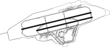
Airports for X-Plane offers a convenient way to explore airports and their related communication information for the X-Plane flight simulator. It only uses data from the X-Plane flight simulator itself, and is therefore more reliable than the data that comes from real aviation websites. You can search for airports by using the ICAO code, or browse for airports per country and state. The information displayed is categorized by airport details, runway information, airport communication, approach frequencies (ILS and Glidepath details), details of nearby beacons, SIDs, STARs and approach procedures.

seaplanes southwest nation international airport air terminal hotel field grass heliport public transport aviation landing area regional buildings faa asphalt consulate military airport apron arrival

Berlin - Berlin Tegel

Airport details

CountryGermany
StateBerlin
RegionED
AirspaceBremen Ctr
Elevation122ft (37m)
TimezoneGMT +1
Coordinates52.55673, 13.29282
Magnetic var
Typeland
Available sinceX-Plane v10.40
ICAO codeEDDT
IATA codeTXL
FAA coden/a

Communication

No airport communication available for EDDT
Nearby Points of Interest:
Jungfernheide
-
Justizvollzugsanstalt Tegel
-
Julius-Leber-Kaserne
-
St. Bernhard
-
St. Joseph-Kirche
-
Friedrich-Ebert-Siedlung
-
BVG-Autobus-Betriebshof mit Wohnanlage
-
Allerheiligenkirche
-
Meilenwerk Berlin
-
Westhafen
-
Paul-Gerhardt-Stift
-
Karl-Bonhoeffer-Nervenklinik
-
Virchow Klinikum
-
St. Philippus-Apostel-Kirchhof
-
Feuerwache Schillerpark
-
Borsig-Villa Reiherwerder
-
Kiosk Seestraße (Berlin-Wedding)
-
Preußisches Institut für Infektionskrankheiten
-
Weiße Stadt
-
Ledigenheim für Männer
-
Rathaus Wedding
-
Bauernhof Großkopf
-
Karl-Schrader-Haus
-
Amtshaus Reinickendorf
-
Charlottenburg Town Hall

Runway info

Runway 08L / 26R  
 length3014m (9888ft)
 bearing84° / 264°
 width46m (151ft)
 surfaceasphalt
 blast zone66m (217ft) / 70m (230ft)
Runway 08R / 26L  
 length2409m (7904ft)
 bearing84° / 264°
 width46m (151ft)
 surfaceasphalt
 displ threshold99m (325ft) / 211m (692ft)
 blast zone50m (164ft) / 72m (236ft)

Nearby beacons

codeidentifierdistbearingfrequency
SDDDME13.3131°114.40
BBIBERLIN BRANDENBURG VOR/DME14.1143°114.10
LWBLOEWENBERG VOR/DME21.9336°114.55
FWEFUERSTENWALDE VOR/DME31.8100°113.30
KLFKLASDORF VOR/DME33.7153°115.15
HOZHOLZDORF TACAN47.5187°117.25
HOZHOLZDORF NDB47.7194°406

Disclaimer

The information on this website is not for real aviation. Use this data with the X-Plane flight simulator only! Data taken with kind consent from X-Plane 12 source code and data files. Content is subject to change without notice.